Search results
Pages
-
-
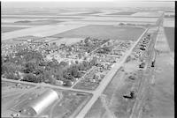
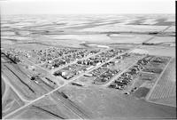
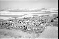
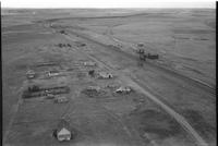
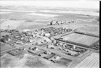
Title
-
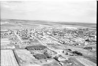
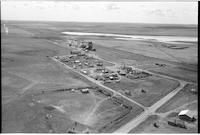
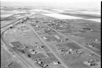
Eatonia
-
Description
-
Aerial photograph of a small town surrounded by agricultural land. The main street and train tracks run parallel. Visible structures include a quonset, a church, and grain elevators.
-
-
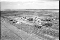
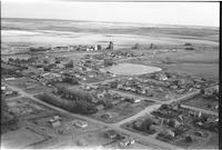
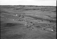
Title
-
Carmichael
-
Description
-
Aerial photograph of a small town. Grain elevators, railway tracks and farmland are also visible.
-
-
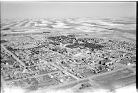
Title
-
Eatonia
-
Description
-
Aerial photograph of a small town
-
-
Title
-
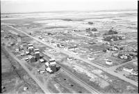
Richmound
-
Description
-
Aerial photograph of a village. An expanse of farmland is visible in the background.
-
Date
-
, 1956
-
-
Title
-
Rush Lake
-
Description
-
Aerial photograph of a village. An expanse of farmland is visible in the background.
-
-
Title
-
Richmound
-
Description
-
Aerial photograph of a village. An expanse of farmland is visible in the background.
-
Date
-
, 1956
-
-
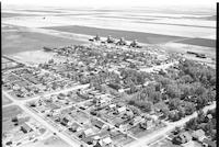
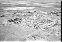
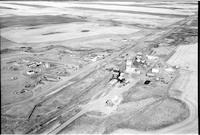
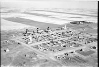
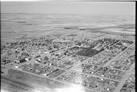
Title
-
Eatonia
-
Description
-
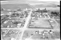
Aerial photograph of a small town with houses, churches, lumber yard, vehicles andtrain station with a train passing through. Agricultural land is visible in the background.
-
-
Title
-
Dunblane
-
Description
-
Aerial photograph of a small town containing several grain elevators. A stretch of farmland is visible in the background.
-
Date
-
, 1955
-

-
Title
-
Mendham
-
Description
-
Aerial photograph of a small community. An expanse of farmland is visible in the background.
-
Date
-
, 1956
-
-
Title
-
Mendham
-
Description
-
Aerial photograph of a small town. An expanse of farmland is visible in the background.
-
Date
-
, 1956
-
-
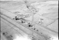
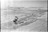
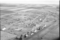
Title
-
Hughton
-
Description
-
Aerial photograph of a hamlet lined by grain elevators, with farmland in the background.
-
-
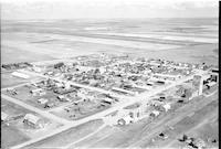
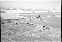
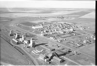
Title
-
Gull Lake
-
Description
-
Aerial photograph of a small town surrounded by farm land. A farm lies on the outskirts of the town. Grain elevators are visible on the far side of town.
-
-
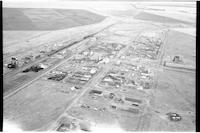
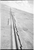
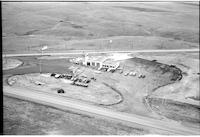
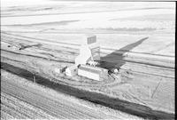
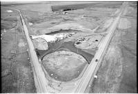
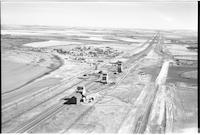
Title
-
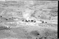
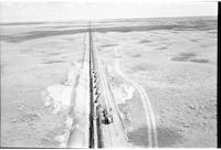
pipeline
-
Description
-
Aerial photograph of the construction of the Trans Canada pipeline, 18 miles south of Lancer.
-
Date
-
, 1956
-
-
Title
-
Hallonquist
-
Description
-
Aerial photograph of a hamlet, near a slough.
-
Date
-
, 1955
-
-
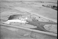
Title
-
Esso Service Station
-
Description
-
Aerial photograph of the Esso Service Station in Swift Current, Saskatchewan.
-
-
Title
-
Tichfield
-
Description
-
Aerial photograph of an unincorporated hamlet nestled in a number of a small hills.
-
Date
-
, 1955
-
-
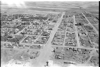
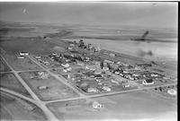
Title
-
Shaunavon
-
Description
-
Aerial photograph of a town with a focus on the main street.
-

-
Title
-
Valor
-
Description
-
Aerial photograph of a community dominated by farmland.
-
Date
-
, 1955
-

-
Title
-
Shackleton
-
Description
-
Aerial photograph of a small agricultural community surrounded by an expanse of farmland.
-
-
Title
-
Simmie
-
Description
-
Aerial photograph of a hamlet with expansive farmland in the background.
-
-
Title
-
Gouverneur
-
Description
-
Aerial photograph of 3 grain elevators, farmhouses, access roads, barns and agricultural land.
-
-
Title
-
pipeline: Trans Canada 18 miles south of Lancer
-
Description
-
Aerial photograph of the construction of the Trans Canada pipeline, 18 miles south of Lancer.
-
Date
-
, 1956
-

-
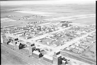
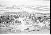
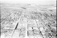
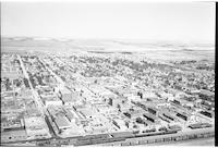
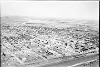
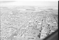
Title
-
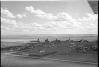
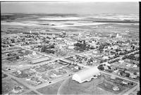
Swift Current
-
Description
-
Aerial photograph of a small city with a bridge over the railway. In the foreground is an experimental farm.
-
Date
-
, 1955
-
-
Title
-
Tuberose
-
Description
-
Aerial photograph of a hamlet surrounded by a vast expanse of farmland.
-
Date
-
, 1956
-
-
Title
-
Vanguard
-
Description
-
Aerial photograph of a village surrounded by farm land. Main street, the railroad, and grain elevators are the most visible features.
-
-
Title
-
Swift Current
-
Description
-
Aerial photograph of a small city in southern Saskatchewan. An expanse of farmland is visible in the background.
-
-
Title
-
Esso Service Station
-
Description
-
Aerial photograph of the Esso Service Station in Swift Current, Saskatchewan.
-
-
Title
-
Wyatt
-
Description
-
Aerial photograph of a small community with expansive farmland in the background.
-
-
Title
-
Vanguard
-
Description
-
Aerial photograph of a village surrounded by farm land. Main street, the railroad, grain elevators, and a quonset dominate the scene.
-
-
Title
-
Tompkins
-
Description
-
Aerial photograph of a village with farm land beyond the town. Grain elevators, the railroad, and a hotel are clearly visible.
-
-
Title
-
Shaunavon
-
Description
-
Aerial photograph of a town with a checkerboard of farmland in the background.
-
-
Title
-
Shaunavon
-
Description
-
Aerial photograph of a town. The upper half of the picture is farm land.
-
-
Title
-
Verlo
-
Description
-
Aerial photograph of a hamlet surrounded by a vast expanse of farmland.
-
Date
-
, 1956
-
-
Title
-
pipeline: Trans Canada 18 miles south of Lancer
-
Description
-
Aerial photograph of the construction of the Trans Canada pipeline, 18 miles south of Lancer.
-
Date
-
, 1956
-
-
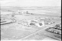
Title
-
Gull Lake
-
Description
-
Aerial photograph of a small town surrounded by farm land. The most visible buildings are a quonset and several grain elevators.
-
-
Title
-
Webb
-
Description
-
Aerial photograph of a village with expansive farmland in the background.
-
-
Title
-
Sidewood
-
Description
-
Aerial photograph of a hamlet. In the background is expansive farmland, with slightly rolling hills.
-
-
Title
-
South Fork
-
Description
-
Aerial photograph of a very small agricultural town. Today, South Fork is a ghost town in Saskatchewan.
-
Date
-
, 1956
-
-
Title
-
Swift Current
-
Description
-
Aerial photograph of a small city in southern Saskatchewan. An expanse of farmland is visible in the background.
-

-
Title
-
Tyner
-
Description
-
Aerial photograph of a hamlet surrounded by treeless farmland.
-
Date
-
, 1956
-
-
Title
-
White Bear
-
Description
-
Aerial photograph of a hamlet surrounded by farmland.
-
Date
-
, 1956
-
-
Title
-
Inglenook
-
Description
-
Aerial photograph of a community.
-
Date
-
, 1956
-
-
Title
-
Swift Current
-
Description
-
Aerial photograph of a small city in southern Saskatchewan. An expanse of farmland is visible in the background.
-
-
Title
-
Wymark
-
Description
-
Aerial photograph of a hamlet with all the structures quite spread out.
-
Date
-
, 1956
-
-
Title
-
Wymark
-
Description
-
Aerial photograph of a hamlet with its infrastructure quite spread out.
-
-
Title
-
Shackleton
-
Description
-
Aerial photograph of a small community surrounded by farmland.
-
-
Title
-
Swift Current
-
Description
-
Aerial photograph of a small city. An expanse of farm land is beyond the town.
-
Date
-
, 1956
-
-
Title
-
Esso Service Station
-
Description
-
Aerial photograph of the Esso Service Station in Swift Current, Saskatchewan.
-
-
Title
-
Tuxford
-
Description
-
Aerial photograph of a small rural community surrounded by an expanse of treeless farmland.
-
-
Title
-
Waldeck
-
Description
-
Aerial photograph of a village surrounded by farmland.
Pages


