Search results
Pages
-
-
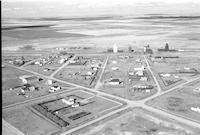
Title
-
New Dayton
-
Description
-
Aerial photograph of New Dayton, a hamlet in Southern Alberta.
-
Date
-
1956
-

-
Title
-
Stanmore
-
Description
-
Aerial photograph of Stanmore, a locality in Southern Alberta. The locality contains one grain elevator and is surrounded by farmland.
-
Date
-
1956
-
-
Title
-
Star
-
Description
-
Aerial photograph of Star, a hamlet in Central Alberta, containing several grain elevators. An expanse of farmland is visible surrounding the locality.
-
Date
-
1956
-
-
Title
-
Star
-
Description
-
Aerial photograph of Star, a hamlet in Central Alberta, containing several grain elevators. An expanse of farmland is visible surrounding the locality.
-
Date
-
1956
-
-
Title
-
Stavely
-
Description
-
Aerial photograph of Stavely, a farming community in Southern Alberta, containg several grain elevators.
-
Date
-
1956
-
-
Title
-
Stavely
-
Description
-
Aerial photograph of Stavely, a farming community in Southern Alberta, containg several grain elevators.
-
Date
-
1956
-
-
Title
-
Stirling
-
Description
-
Aerial photograph of Stirling, a village in Southern Alberta. An expanse of farmland is visible in the background.
-
Date
-
1956
-
-
Title
-
Stony Plain
-
Description
-
Aerial photograph of Stony Plain, a town in the Edmonton Capital Region of Alberta, containing several grain elevators. An expanse of farmland is visible in the background.
-
Date
-
1957-07-01
-
-
Title
-
Stony Plain
-
Description
-
Aerial photograph of Stony Plain, a town in the Edmonton Capital Region of Alberta. Am expanse of farmland is visible in the background.
-
Date
-
1957-07-01
-
-
Title
-
Sexsmith
-
Description
-
Aerial photograph of Sexmith, a town in Northern Alberta, containing several grain elevators. An expanse of farmland is visible in the background.
-
Date
-
1956
-
-
Title
-
Sexsmith
-
Description
-
Aerial photograph of Sexmith, a town in Northern Alberta, containing several grain elevators. Farmland is visible to the left and in the background.
-
Date
-
1956
-
-
Title
-
Silverwood
-
Description
-
Aerial photograph of Silverwood, a locality in Northern Alberta, containing a grain elevator. An expanse of farmland surrounds the locality.
-
Date
-
1956
-
-
Title
-
Three Hills
-
Description
-
Aerial photograph of Three Hills, a town in Central Alberta, containing several grain elevators.
-
Date
-
1956
-
-
Title
-
Three Hills
-
Description
-
Aerial photograph of Three Hills, a town in Central Alberta.
-
Date
-
1956
-
-
Title
-
Tofield
-
Description
-
Aerial photograph of Tofield, a town in Central Alberta.
-
-
Title
-
Tofield
-
Description
-
Aerial photograph of Tofield, a town in Central Alberta.
-
Date
-
1956-09-28
-
-
Title
-
Trochu
-
Description
-
Aerial photograph of Trochu, a town in Southern Alberta, containing several grain elevators. An expanse of farmland is visible in the background.
-
-
Title
-
Streamstown
-
Description
-
Aerial photograph of Streamstown, a hamlet in Central Alberta, containing two grain elevators. An expanse of farmland surrounds the hamlet.
-
Date
-
1956
-
-
Title
-
Sullivan Lake
-
Description
-
Aerial photograph of Sullivan Lake in Southern Alberta.
-
Date
-
1956
-
-
Title
-
Sullivan Lake
-
Description
-
Aerial photograph of Sullivan Lake in Southern Alberta.
-
Date
-
1956
-
-
Title
-
Sunnyslope
-
Description
-
Aerial photograph of Sunnyslope, a hamlet in Southern Alberta surrounded by expansive farmland.
-
Date
-
1956
-
-
Title
-
Swalwell
-
Description
-
Aerial photograph of Swalwell, a hamlet in Southern Alberta, containing three grain elevators. An expanse of farmland is visible in the background.
-
Date
-
1956
-
-
Title
-
Swalwell
-
Description
-
Aerial photograph of Swalwell, a hamlet in Southern Alberta surrounded by expansive farmland.
-
Date
-
1956
-
-
Title
-
Three Hills
-
Description
-
Aerial photograph of Three Hills, a town in Central Alberta.
-
Date
-
1956
-
-
Title
-
Three Hills
-
Description
-
Aerial photograph of Three Hills, a town in Central Alberta.
-
Date
-
1956
-
-
Title
-
Vermilion
-
Description
-
Aerial photograph of Vermilion, a town in Central Alberta.
-
-
Title
-
Vermilion
-
Description
-
Aerial photograph of Vermilion, a town in Central Alberta, containing several grain elevators.
-
-
Title
-
Viking
-
Description
-
Aerial photograph of Viking, a town in Central Alberta, containing several grain elevators. An expanse of farmland is visble in the background.
-
-
Title
-
Viking
-
Description
-
Aerial photograph of Viking, a town in Central Alberta. An expanse of farmland is visible in the background.
-
-
Title
-
Villeneuve
-
Description
-
Aerial photograph of Vileneuve, a hamlet in Central Alberta, containing three gran elevators. An expanse of farmland surrounds the hamlet.
-
Date
-
1956
-
-
Title
-
Vilna
-
Description
-
Aerial photograph of Vilna, a village in Central Alberta. An expanse of farmland and clusters of trees are visible in the background.
-
Date
-
1956
-
-
Title
-
Vilna
-
Description
-
Aerial photograph of Vilna, a village in Central Alberta. An expanse of farmland and clusters of trees are visible in the background.
-
Date
-
1956
-
-
Title
-
Twining
-
Description
-
Aerial photograph of Twining, a town in Southern Alberta surrounded by farmland.
-
-
Title
-
Two Hills
-
Description
-
Aerial photograph of Three Hills, a town in Central Alberta. An expanse of farmland is visible in the background.
-
Date
-
1957-07-01
-
-
Title
-
Vegreville
-
Description
-
Aerial photograph of Vegreville, a town in Central Alberta. An expanse of farmland is visible in the background.
-
-
Title
-
Vegreville
-
Description
-
Aerial photograph of Vegreville, a town in Central Alberta. An expanse of farmland is visible in the background.
-
Date
-
1956
-
-
Title
-
Vermilion
-
Description
-
Aerial photograph of the Vermilion School of Agriculture in Alberta surrounded by farmland.
-
Date
-
1953
-
-
Title
-
Wildwood
-
Description
-
Aerial photograph of Wildwood, a hamlet in Central Alberta.
-
Date
-
1957-07-01
-
-
Title
-
Woking
-
Description
-
Aerial photograph of Woking, a hamlet in northwestern Alberta, containing two grain elevators.
-
Date
-
1956
-
-
Title
-
Woodhouse
-
Description
-
Aerial photograph of Woodhouse, a hamlet in Southern Alberta, containing several grain elevators.
-
Date
-
1956
-
-
Title
-
Wostok
-
Description
-
Aerial photograph of Wostok, a hamlet in Central Alberta, containing several grain elevators.
-
Date
-
1956
-
-
Title
-
Youngstown
-
Description
-
Aerial photograph of Youngstown, a village in Southern Alberta. An expanse of farmland is visible in the background.
-
Date
-
1956
-
-
Title
-
Wetaskiwin
-
Description
-
Aerial photograph of Wetaskiwin No. 10, a small city in Central Alberta. An expanse of farmland is visible in the background.
-
-
Title
-
Wetaskiwin
-
Description
-
Aerial photograph of Wetaskiwin No. 10, a small city in Central Alberta. An expanse of farmland is visible in the background.
-
-
Title
-
Wetaskiwin
-
Description
-
Aerial photograph of Wetaskiwin No. 10, a small city in Central Alberta. An expanse of farmland is visible in the background.
-
-
Title
-
Whiskey Gap
-
Description
-
Aerial photograph of Whiskey Gap, a former town in Southern Alberta, containing three grain elevators surrounded by farmland.
-
Date
-
1956
-
-
Title
-
Whitelaw
-
Description
-
Aerial photograph of Whitelaw, a hamlet in Northern Alberta, containing several grain elevators. An expanse of farmland surrounds the hamlet.
-
-
Title
-
Whitford
-
Description
-
Aerial photograph of Whitford, a hamlet in Central Alberta, containing three grain elevators. The hamlet is surrounded by farmland.
-
-
Title
-
Whitford
-
Description
-
Aerial photograph of Whitford, a hamlet in Central Alberta, containing three grain elevators along a railroad siding. The hamlet is surrounded by farmland.
-
-
Title
-
Whitla
-
Description
-
Aerial photograph of Whitla, a community in Southern Alberta, containing two grain elevators, houses and a church. The community is surrounded by farmland.
Pages


