Error message
Warning: count(): Parameter must be an array or an object that implements Countable in theme_pager_link() (line 637 of /opt/rh/httpd24/root/var/www/html/drupal/web/includes/pager.inc).
Search results
Pages
-
-
Title
-
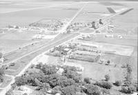
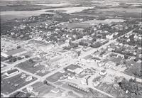
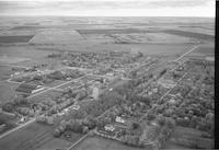
Elie
-
Description
-
Aerial photograph of Elie, a local urban district in in the Central Plains Region of Manitoba.
-
Date
-
1956
-
-
Title
-
Elva
-
Description
-
Aerial photograph of Elva, a community in south-western Manitoba.
-
Date
-
1956
-
-
Title
-
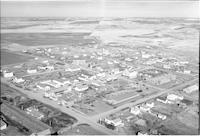
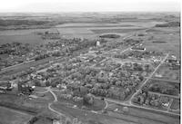
Gilbert Plains
-
Description
-
Aerial photograph of Gilbert Plains, an urban community in the Parkland Region of Manitoba.
-
Date
-
1956
-
-
Title
-
Gladstone
-
Description
-
Aerial photograph of Gladstone, an urban community in the Parkland Region of Manitoba that held town status prior to 2015.
-
-
Title
-
Gilbert Plains
-
Description
-
Aerial photograph of Gilbert Plains, an urban community in the Parkland Region of Manitoba.
-
Date
-
1956
-
-
Title
-
Grosse Isle
-
Description
-
Aerial photograph of Grosse Isle, a small rural community located between the Rural Municipality of Rosser and the Rural Municipality of Rockwood in Manitoba.
-
Date
-
1956
-
-
Title
-
Hanley
-
Description
-
Aerial photograph of Hanley, a town in Saskatchewan. An expanse of farmland is visible in the background.
-
-
Title
-
Hanley
-
Description
-
Aerial photograph of Hanley, a town in central Saskatchewan. Several grain elevators are visible in the left. An expanse of farmland is visible in the background.
-
-
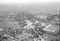
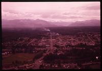
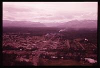
Title
-
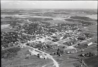
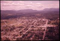
Hartney
-
Description
-
Aerial photograph of Hartney, a town in southwest Manitoba. Two grain elevators are visible in the center. An expanse of farmland is visible in the background.
-
Date
-
1958
-
-
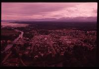
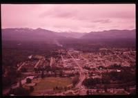
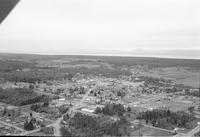
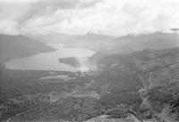
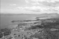
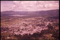
Title
-
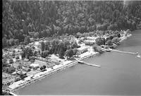
Harrison Hot Springs
-
Description
-
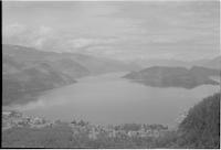
Aerial photograph of Harrison Hot Springs, a small community along Harrison Lake in the Fraser Valley of British Columbia.
-
Date
-
1958
-
-
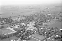
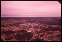
Title
-
Hartney
-
Description
-
Aerial photograph of Hartney, a town in southwest Manitoba. An expanse of farmland is visible in the background.
-
Date
-
1958
-
-
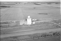
Title
-
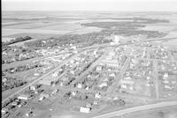
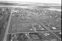
High Bluff
-
Description
-
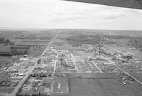
Aerial photograph of High Bluff, a populated community in the Central Plains Region of Manitoba, containing one grain elevator. An expanse of farmland is visible in the background.
-
Date
-
1956
-
-
Title
-
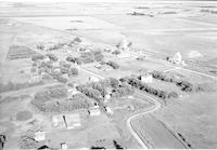
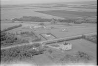
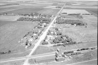
Howden
-
Description
-
Aerial photograph of a railroad siding in Howden, a hamlet in eastern Manitoba. An expanse of farmland is visible in the background.
-
Date
-
1956
-
-
Title
-
Ashcroft
-
Description
-
Aerial photograph of Ashcroft, a village in the Thompson Country of the Interior of British Columbia.
-
Date
-
1960
-
-
Title
-
Ashcroft
-
Description
-
Aerial photograph of Ashcroft, a village in the Thompson Country of the Interior of British Columbia.
-
Date
-
1960
-
-
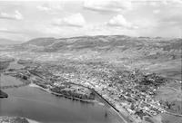
Title
-
Armstrong
-
Description
-
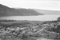
Aerial photograph of the City of Armstrong located on the North Okanagan, British Columbia.
-
Date
-
1960
-
-
Title
-
Boston Bar
-
Description
-
Aerial photograph of Boston Bar, a town in British Columbia.
-
Date
-
1960
-
-
Title
-
Boston Bar
-
Description
-
Aerial photograph of Boston Bar, a town in British Columbia.
-
Date
-
1960
-
-
Title
-
Canoe
-
Description
-
Aerial photograph of Canoe, a semi-rural community in British Columbia.
-
Date
-
1960
-
-
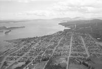
Title
-
Courtenay
-
Description
-
Aerial photograph of Courtenay, a city on the east coast of Vancouver Island, British Columbia.
-
Date
-
1960
-
-
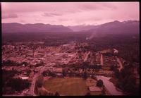
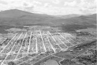
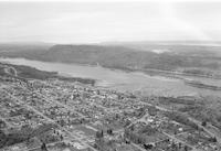
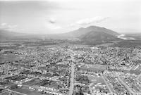
Title
-
Kamloops
-
Description
-
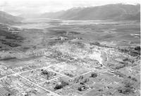
Aerial photograph of Kamloops, a city in south-central British Columbia.
-
Date
-
1960
-
-
Title
-
Kamloops
-
Description
-
Aerial photograph of Kamloops, a city in south-central British Columbia.
-
Date
-
1960
-
-
Title
-
Jarvis
-
Description
-
Aerial photograph of Jarvis, a small community in the south of Ontario.
-
Date
-
1960
-
-
Title
-
Jarvis
-
Description
-
Aerial photograph of Jarvis, a small community in the south of Ontario.
-
Date
-
1960
-
-
Title
-
Courtenay
-
Description
-
Aerial photograph of Courtenay, a city on the east coast of Vancouver Island, British Columbia.
-
Date
-
1960
-
-
Title
-
Courtenay
-
Description
-
Aerial photograph of Courtenay, a city on the east coast of Vancouver Island, British Columbia.
-
Date
-
1960
-
-
Title
-
Courtenay
-
Description
-
Aerial photograph of Courtenay, a city on the east coast of Vancouver Island, British Columbia.
-
Date
-
1960
-
-
Title
-
Courtenay
-
Description
-
Aerial photograph of Courtenay, a city on the east coast of Vancouver Island, British Columbia.
-
Date
-
1960
-
-
Title
-
Courtenay
-
Description
-
Aerial photograph of Courtenay, a city on the east coast of Vancouver Island, British Columbia.
-
Date
-
1960
-
-
Title
-
Courtenay
-
Description
-
Aerial photograph of Courtenay, a city on the east coast of Vancouver Island, British Columbia.
-
Date
-
1960
-
-
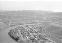
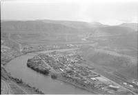
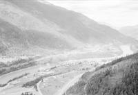
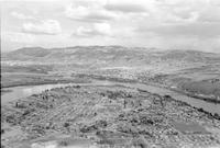
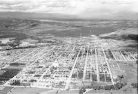
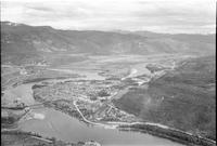
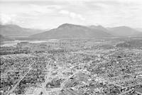
Title
-
Cranbrook
-
Description
-
Aerial photograph of Cranbrook, a city in southeast British Columbia.
-
Date
-
1960
-
-
Title
-
Cranbrook
-
Description
-
Aerial photograph of Cranbrook, a city in southeast British Columbia.
-
Date
-
1960
-
-
Title
-
Ladysmith
-
Description
-
Aerial photograph of Ladysmith, a town on the east coast of Vancouver Island, British Columbia.
-
Date
-
1960
-
-
Title
-
Ladysmith
-
Description
-
Aerial photograph of Ladysmith, a town on the east coast of Vancouver Island, British Columbia.
-
Date
-
1960
-
-
Title
-
Castlegar
-
Description
-
Aerial photograph of Castlegar, a community in the West Kootenay Region of British Columbia.
-
Date
-
1960
-
-
Title
-
Cascade
-
Description
-
Aerial photograph of Cascade, a city in the West Kootenay region of British Columbia.
-
Date
-
1960
-
-
Title
-
Cloverdale
-
Description
-
Aerial photograph of Cloverdale, a town centre in the city of Surrey, British Columbia.
-
Date
-
1960
-
-
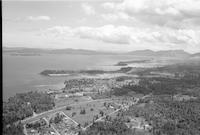
Title
-
Harrison Hot Springs
-
Description
-
Aerial photograph of Harrison Hot Springs, a small community located in the Lower Mainland area of British Columbia.
-
Date
-
1960
-
-
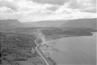
Title
-
Agassiz
-
Description
-
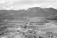
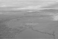
Aerial photograph of a small community in the Eastern Fraser Valley region of British Columbia. A range of mountains is visible in the background.
-
Date
-
1960
-
-
Title
-
Alberni
-
Description
-
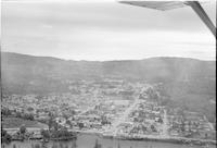
Aerial photograph of a Port Alberni, a port city in the Alberni-Clayoquot Regional District in Vancouver Island.
-
Date
-
1960
-
-
Title
-
Chemainus
-
Description
-
Aerial photograph of Chemainus, a community on the east coast of southern Vancouver Island, British Columbia.
-
Date
-
1960
-
-
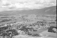
Title
-
Chilliwack
-
Description
-
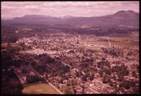
Aerial photograph of Chilliwack, a city located on the Fraser Valley Regional District of British Columbia.
-
Date
-
1960
-
-
Title
-
Chilliwack
-
Description
-
Aerial photograph of Chilliwack, a city located on the Fraser Valley Regional District of British Columbia.
-
Date
-
1960
-
-
Title
-
Chemainus
-
Description
-
Aerial photograph of Chemainus, a community on the east coast of southern Vancouver Island, British Columbia.
-
Date
-
1960
-
-
Title
-
Chase
-
Description
-
Aerial photograph of Chase, a village in British Columbia.
-
Date
-
1960
-
-
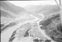
Title
-
Creston
-
Description
-
Aerial photograph of Creston, a town in the Kootenay region of southeastern British Columbia.
-
Date
-
1960
-
-
Title
-
Douglas Lake
-
Description
-
Aerial photograph of Douglas Lake Ranch, a cattle ranch in the Southern Interior of British Columbia.
-
Date
-
1960
-
-
Title
-
Duncan
-
Description
-
Aerial photograph of Duncan, a city on southern Vancouver Island in British Columbia.
-
Date
-
1960
-
-
Title
-
Duncan
-
Description
-
Aerial photograph of Duncan, a city on southern Vancouver Island in British Columbia.
-
Date
-
1960
-
-
Title
-
Duncan
-
Description
-
Aerial photograph of Duncan, a city on southern Vancouver Island in British Columbia.
-
Date
-
1960
Pages


