Error message
Warning: count(): Parameter must be an array or an object that implements Countable in theme_pager_link() (line 637 of /opt/rh/httpd24/root/var/www/html/drupal/web/includes/pager.inc).
Search results
Pages
-

-
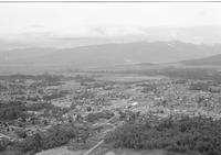
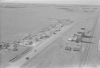
Title
-
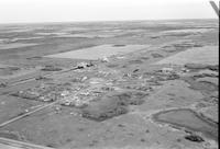
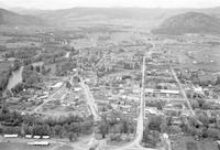
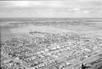
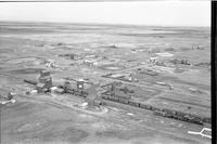
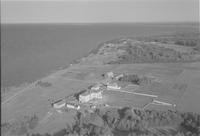
Galloway
-
Description
-
Aerial photograph of Galloway, a community in the Kootenay region of British Columbia.
-
Date
-
1960
-
-
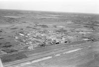
Title
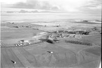
-
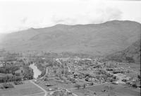
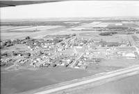
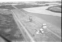
Gadsby
-
Description
-
Aerial photograph of Gadsby, a village in Central Alberta.
-
Date
-
1960
-
-
Title
-
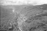
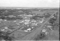
Gem
-
Description
-
Aerial photograph of Gem, a hamlet in Southern Alberta
-
Date
-
1960
-
-
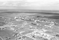
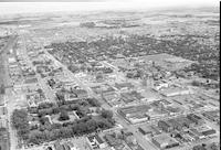
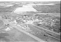
Title
-
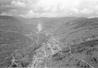
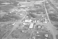
Fort Saskatchewan
-
Description
-
Aerial photograph of Fort Saskatchewan, a city in the Edmonton Metropolitan Region of Alberta.
-
Date
-
1960
-
-
Title
-
Greenwood
-
Description
-
Aerial photograph of Greenwood, a city in south central British Columbia.
-
Date
-
1960
-
-
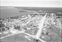
Title
-
Grand Forks
-
Description
-
Aerial photograph of Grand Forks, a city in the Boundary Country of the West Kootenay region of British Columbia.
-
Date
-
1960
-
-
Title
-
Grand Forks
-
Description
-
Aerial photograph of Grand Forks, a city in the Boundary Country of the West Kootenay region of British Columbia.
-
Date
-
1960
-
-
Title
-
Greenwood
-
Description
-
Aerial photograph of Greenwood, a city in south central British Columbia.
-
Date
-
1960
-
-
Title
-
Greenwood
-
Description
-
Aerial photograph of Greenwood, a city in south central British Columbia.
-
Date
-
1960
-
-
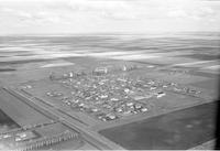
Title
-
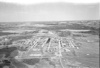
Grassy Lake
-
Description
-
Aerial photograph of Grassy Lake, a hamlet in Southern Alberta.
-
Date
-
1960
-
-
Title
-
Granum
-
Description
-
Aerial photograph of Granum, a town in Southern Alberta.
-
Date
-
1960
-
-
Title
-
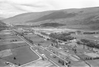
Haney
-
Description
-
Aerial photograph of Haney, the downtown core of the city of Maple Ridge in the northeastern section of Greater Vancouver, British Columbia.
-
Date
-
1960
-
-
Title
-
Halkirk
-
Description
-
Aerial photograph of Halkirk, a village in Central Alberta.
-
Date
-
1960
-
-
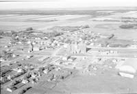
Title
-
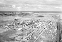
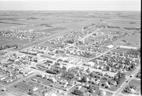
Hanna
-
Description
-
Aerial photograph of Hanna, a town in Southern Alberta.
-
Date
-
1960
-
-
Title
-
Grindrod
-
Description
-
Aerial photograph of Grindod, an unincorporated designated place in the south of British Columbia.
-
Date
-
1960
-
-
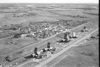
Title
-
Hardisty
-
Description
-
Aerial photograph of Hardisty, a town in Central Alberta.
-
Date
-
1960
-
-
Title
-
Hanna
-
Description
-
Aerial photograph of Hanna, a town in Southern Alberta.
-
Date
-
1960
-
-
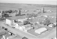
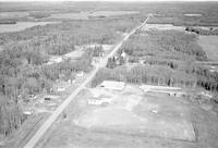
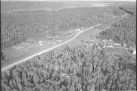
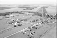
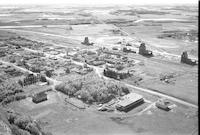
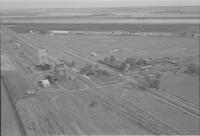
Title
-
Kitscoty
-
Description
-
Aerial photograph of Kitscoty, a village in Central Alberta, including three grain elevators, a general store, and a café. An expanse of farmland is visible in the background.
-
-
Title
-
Lac La Biche
-
Description
-
Aerial photograph of Lac La Biche, a hamlet in Northern Alberta. A lake is visible in the background.
-
-
Title
-
Lac La Biche
-
Description
-
Aerial photograph of a service station 4 miles west of Lac La Biche, Alberta.
-
-
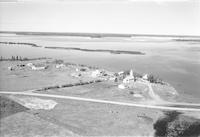
Title
-
Lake Wabamun
-
Description
-
Aerial photograph of Lake Wabamun, Alberta, including cottages and a boat.
-
Date
-
1957-07
-
-
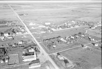
Title
-
Langdon
-
Description
-
Aerial photograph of Langdon, a hamlet in Southern Alberta, including two grain elevators. An expanse of farmland is visible in the background.
-
Date
-
1956
-
-
Title
-
Leduc
-
Description
-
Aerial photograph of Leduc, a former town and now city in the Edmonton Metropolitan Region of Alberta. An expanse of land is visible in the background.
-
-
Title
-
Letellier
-
Description
-
Aerial photograph of Letellier, a community in the Pembina Valley Region of Manitoba, containing multiple grain elevators. An expanse of farmland is visible in the background.
-
Date
-
1956
-
-
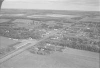
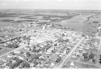
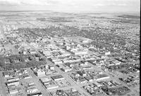
Title
-
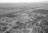
Lethbridge
-
Description
-
Aerial photograph of Lethbridge, a city in Southern Alberta. An expanse of land is visible in the background.
-
Date
-
1956
-
-
Title
-
Lethbridge
-
Description
-
Aerial photograph of Lethbridge, a city in Southern Alberta.
-
Date
-
1956
-
-
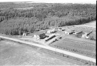
Title
-
Lindale
-
Description
-
Aerial photograph of Lindale, a locality in Central Alberta, surrounded by trees.
-
Date
-
1957-07
-
-
Title
-
Jefferson
-
Description
-
Aerial photograph of Jefferson, an unincorporated community in Southern Alberta, containing three grain elevators.
-
Date
-
1956
-
-
Title
-
Jarrow
-
Description
-
Aerial photograph of Jarrow, a locality in Central Alberta.
-
-
Title
-
Joussard
-
Description
-
Aerial photograph of Joussard, a hamlet in Northern Alberta along the Lesser Slave Lake,which is visible in the left.
-
Date
-
1956
-
-
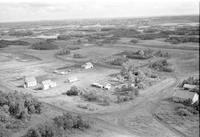
Title
-
Kaleland
-
Description
-
Aerial photograph of Kaleland, a locality in Central Alberta, containing two grain elevators.
-
-
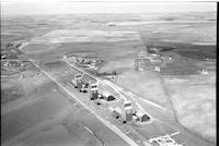
Title
-
Kinsella
-
Description
-
Aerial photograph of Kinsella, a hamlet in Central Alberta.
-
-
Title
-
Kinsella
-
Description
-
Aerial photograph of Kinsella, a hamlet in Central Alberta.
-
-
Title
-
Joussard
-
Description
-
Aerial photograph of Joussard, a hamlet in Northern Alberta along the Lesser Slave Lake, visible in the background.
-
Date
-
1956
-
-
Title
-
Josephburg
-
Description
-
Aerial photograph of Josephburg, a hamlet within the Edmonton Metropolitan Region of Alberta, containing four grain elevators.
-
-
Title
-
Kelwood
-
Description
-
Aerial photograph of Kelwood, a community in western Manitoba, containing a church and two grain elevators. Farmland is visible around the community.
-
Date
-
1956
-
-
Title
-
Keyes
-
Description
-
Aerial photograph of Keyes, a community in the Central Plains Region of Manitoba, including one grain elevator.
-
-
Title
-
Lac La Biche
-
Description
-
Aerial photograph of Lac La Biche, a hamlet in Northern Alberta. A lake is visible to the left.
-
Date
-
1956
-
-
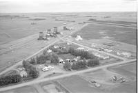
Title
-
La Salle
-
Description
-
Aerial photograph of La Salle, a town in the Winnipeg Capital Region of Manitoba, containing a grain elevator and the St. Hyacinthe Roman Catholic Church. An expanse of farmland is visible in the background.
-
Date
-
1956
-
-
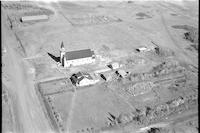
Title
-
Laurier
-
Description
-
Aerial photograph of Laurier, a community in the Parkland Region of Manitoba, including one grain elevator. A church is visible in the foreground and an expanse of farmland is visible in the background.
-
Date
-
1956
-
-
Title
-
Lavoy
-
Description
-
Aerial photograph of Lavoy, a hamlet in Central Alberta, containing several grain elevators. An expanse of farmland is visible in the background.
-
Date
-
1956
-
-
Title
-
Lavoy
-
Description
-
Aerial photograph of Lavoy, a hamlet in Central Alberta, containing several grain elevators. An expanse of farmland is visible in the background.
-
Date
-
1956
-
-
Title
-
Lavoy
-
Description
-
Aerial photograph of Lavoy, a hamlet in Central Alberta, containing several grain elevators.
-
Date
-
1956
-
-
Title
-
Leduc
-
Description
-
Aerial photograph of Leduc, a former town and now city in the Edmonton Metropolitan Region of Alberta, containing multiple grain elevators. Telford Lake is visible in the background.
-
-
Title
-
Letellier
-
Description
-
Aerial photograph of Letellier, a community in the Pembina Valley Region of Manitoba, containing multiple grain elevators. An expanse of farmland is visible in the background.
-
Date
-
1956
-
-
Title
-
Lethbridge
-
Description
-
Aerial photograph of Lethbridge, a city in Southern Alberta.
-
Date
-
1956
-
-
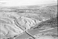
Title
-
Lethbridge
-
Description
-
Aerial photograph of Lethbridge, a city in Southern Alberta. The Oldman River is visible in the foreground. The Lethbridge Viaduct is visible to the right.
-
Date
-
1956
-
-
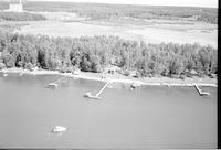
Title
-
Jackfish Lake
-
Description
-
Aerial photograph of a church in Jackfish, a hamlet in Saskatchewan. A cemetery is visible in the background.
-
-
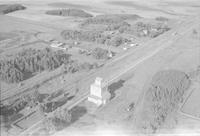
Title
-
Kathryn
-
Description
-
Aerial photograph of Kathryn, a hamlet in Southern Alberta, containing two grain elevators. An expanse of farmland is visible in the background.
-
Date
-
1956
-
-
Title
-
Kavanagh
-
Description
-
Aerial photograph of Kavanagh, a hamlet in the Edmonton Metropolitan Region of Alberta, containing two grain elevators. An expanse of farmland is visible in the background.
Pages


