Error message
Warning: count(): Parameter must be an array or an object that implements Countable in theme_pager_link() (line 637 of /opt/rh/httpd24/root/var/www/html/drupal/web/includes/pager.inc).
Search results
Pages
-
-
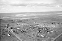
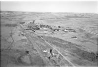
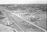
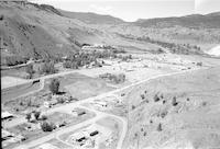
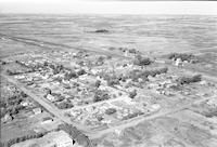
Title
-
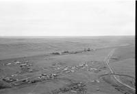
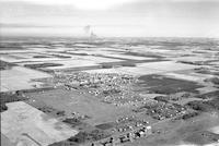
Walsh
-
Description
-
Aerial photograph of Walsh, a hamlet in Southern Alberta.
-
Date
-
1960
-
-
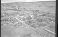
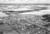
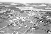
Title
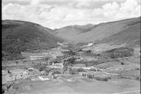
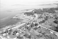
-
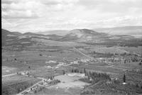
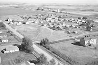
Westbank
-
Description
-
Aerial photograph of Westbank, a community within the City of West Kelowna in British Columbia.
-
Date
-
1960
-
-
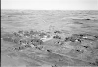
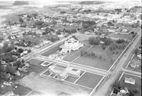
Title
-
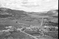
Westbank
-
Description
-
Aerial photograph of Westbank, a community within the City of West Kelowna in British Columbia.
-
Date
-
1960
-
-
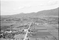
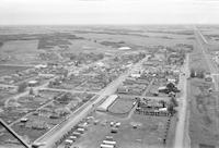
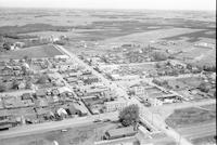
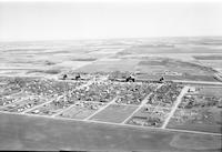
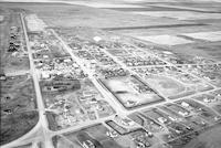
Title
-
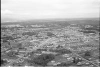
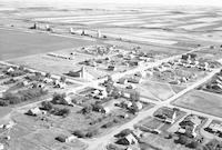
Whalley
-
Description
-
Aerial photograph of Whalley, the downtown district of the City of Surrey in British Columbia.
-
Date
-
1960
-
-
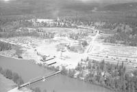
Title
-
Wynndel
-
Description
-
Aerial photograph of Wynndel, a small rural community in the Kootenay Region of British Columbia.
-
Date
-
1960
-
-
Title
-
Yarrow
-
Description
-
Aerial photograph of Yarrow, a small community within the City of Chilliwack in British Columbia.
-
Date
-
1960
-
-
Title
-
Yale
-
Description
-
Aerial photograph of Yale, an unincorporated community in British Columbia.
-
Date
-
1960
-
-
Title
-
Ymir
-
Description
-
Aerial photograph of Ymir, a small town in the Kootenay region of British Columbia.
-
Date
-
1960
-
-
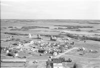
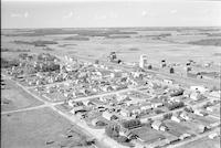
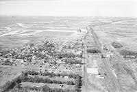
Title
-
Youngstown
-
Description
-
Aerial photograph of Youngstown, a village in Southern Alberta.
-
Date
-
1960
-
-
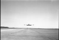
Title
-
Aircraft
-
Description
-
Photograph of a T-33 Thunderbird aircraft.
-
-
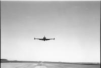
Title
-
Aircraft
-
Description
-
Photograph of a T-33 Thunderbird aircraft.
-
-
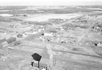
Title
-
Lindbergh
-
Description
-
Aerial photograph of Lindbergh, a hamlet in Northern Alberta.
-
Date
-
1960
-
-
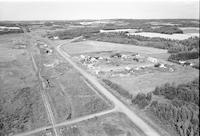
Title
-
Monitor
-
Description
-
Aerial photograph of Monitor, a hamlet in Central Alberta.
-
-
Title
-
Monitor
-
Description
-
Aerial photograph of Monitor, a hamlet in Central Alberta.
-
-
Title
-
Monitor
-
Description
-
Aerial photograph of Monitor, a hamlet in Central Alberta.
-

-
Title
-
Mundare
-
Description
-
Aerial photograph of Mundare, a small town in Central Alberta.
-
-
Title
-
Mundare
-
Description
-
Aerial photograph of Mundare, a small town in Central Alberta.
-
-
Title
-
Musidora
-
Description
-
Aerial photograph of Musidora, a hamlet in Central Alberta.
-
-
Title
-
Mundare
-
Description
-
Aerial photograph of Mundare, a small town in Central Alberta.
-

-
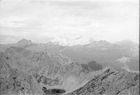
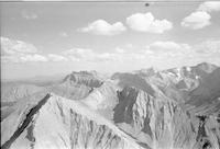
Title
-
Mountain scenes
-
Description
-
Aerial photograph of an unidentified range of mountains in British Columbia.
-
-
Title
-
Mountain scenes
-
Description
-
Aerial photograph of an unidentified range of mountains in British Columbia.
-
-
Title
-
Minburn
-
Description
-
Aerial photograph of Minburn, a hamlet in Central Alberta, containing several grain elevators. A body of water and an expanse of land are visible in the background.
-
-
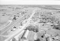
Title
-
Millet
-
Description
-
Aerial photograph of Millet, a town in Central Alberta, including four grain elevators. An expanse of land is visible in the background.
-

-
Title
-
Minburn
-
Description
-
Aerial photograph of Minburn, a hamlet in Central Alberta, containing several grain elevators.
-
-
Title
-
Millet
-
Description
-
Aerial photograph of Millet, a town in Central Alberta, including four grain elevators, a hotel, and a service station.
-
-
Title
-
Morecambe
-
Description
-
Aerial photograph of Morecambe, a hamlet in Central Alberta.
-
-
Title
-
Mountain scenes
-
Description
-
Aerial photograph of a range of mountains in British Columbia.
-

-
Title
-
Mallaig
-
Description
-
Aerial photograph of Mallaig, a settlement in Northern Alberta surrounded by farmland. Several grain elevators and churches are visible.
-
-
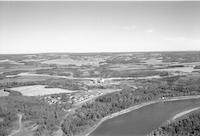
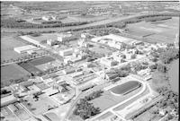
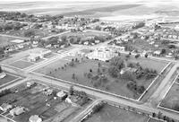
Title
-
Manitoba Agriculture College
-
Description
-
Aerial photograph of the Manitoba Agriculture College. The Assiniboine River is visible in the background.
-
-
Title
-
Metiskow
-
Description
-
Aerial photograph of Metiskow, a hamlet in Central Alberta.
-
-
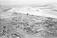
Title
-
Cabri
-
Description
-
Aerial photograph of Cabri, a town in southwest Saskatchewan. An expanse of farmland is visible in the background.
-
-
Title
-
Cabri
-
Description
-
Aerial photograph of Cabri, a town in southwest Saskatchewan. An expanse of farmland is visible in the background.
-

-
Title
-
Copper Cliff
-
Description
-
Aerial photograph of the Copper Cliff South Mine in Northern Ontario.
-
-
Title
-
Copper Cliff
-
Description
-
Aerial photograph of the Copper Cliff South Mine in Northern Ontario.
-
-
Title
-
Calmar
-
Description
-
Aerial photograph of Calmar, a town in Central Alberta. An extanse of farmland is visible around the town. Smoke is visible in the background.
-
Date
-
1960
-
-
Title
-
Cadillac
-
Description
-
Aerial photograph of Cadillac, a village in southwest Saskatchewan. Several grain elevators and an expanse of farmland are visible in the background.
-
-
Title
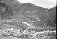
-
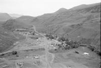
Cache Creek
-
Description
-
Aerial photograph of Cache Creek, a village in the Thompson Country in British Columbia.
-
Date
-
1960
-
-
Title
-
Cadillac
-
Description
-
Aerial photograph of Cadillac, a village in southwest Saskatchewan. Several grain elevators and an expanse of farmland are visible in the background.
-
-
Title
-
Cache Creek
-
Description
-
Aerial photograph of Cache Creek, a village in the Thompson Country in British Columbia.
-
-
Title
-
Calmar
-
Description
-
Aerial photograph of Calmar, a town in Central Alberta surrounded by farmland.
-
Date
-
1960
-
-
Title
-
Cardston
-
Description
-
Aerial photograph of Cardston, a town in southwest Alberta, containing the Cardston Alberta Temple at the center of the image. A church is visible in the foreground. An expanse of farmland is visible in the background.
-
-
Title
-
Carnduff
-
Description
-
Aerial photograph of Carnduff, a town in southeast Saskatchewan.
-
Date
-
1961
-
-
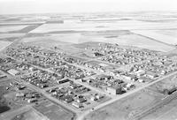
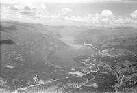
Title
-
Cascade
-
Description
-
Aerial photograph of Cascade, a former town in the south of British Columbia. Christina Lake is visible in background.
-
-
Title
-
Campbell River
-
Description
-
Aerial photograph of a rural route in Campbell River, British Columbia.
-
-
Title
-
Cardston
-
Description
-
Aerial photograph of Cardston, a town in southwest Alberta, containing the Cardston Alberta Temple. An expanse of farmland is visible in the background.
-
-
Title
-
Chaplin
-
Description
-
Aerial photograph of Chaplin, a village in south central Saskatchewan.
-
-
Title
-
Chaplin
-
Description
-
Aerial photograph of Chaplin, a village in south central Saskatchewan.
-
-
Title
-
Clive
-
Description
-
Aerial photograph of Clive, a village in Central Alberta, containing several grain elevators. An expanse of farmland is visible in the background.
-
-
Title
-
Climax
-
Description
-
Aerial photograph of Climax, a village in southwest Saskatchewan.
-
-
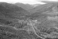
Title
-
Clearwater
-
Description
-
Aerial photograph of Clearwater, British Columbia.
Pages


