Error message
Warning: count(): Parameter must be an array or an object that implements Countable in theme_pager_link() (line 637 of /opt/rh/httpd24/root/var/www/html/drupal/web/includes/pager.inc).
Search results
Pages
-
-
Title
-
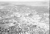
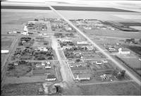
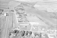
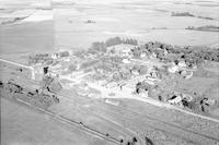
Dauphin
-
Description
-
Aerial photograph of the City of Dauphin in Manitoba.
-
Date
-
1956
-
-
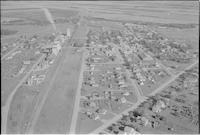
Title
-
Headingley
-
Description
-
Aerial photograph of Headingley, an unincorporated community in the Winnipeg Capital Region of Manitoba. An expanse of farmland is visible in the background.
-
Date
-
1956
-
-
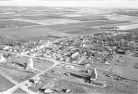
Title
-
High Bluff
-
Description
-
Aerial photograph of High Bluff, a populated community in the Central Plains Region of Manitoba, containing two grain elevators. An expanse of farmland is visible in the background.
-
Date
-
1956
-
-
Title
-
Holland
-
Description
-
Aerial photograph of Holland, an unincorporated community in the Central Plains Region of Manitoba, containing two grain elevators. An expanse of farmland is visible in the background.
-
-
Title
-
Arnaud
-
Description
-
Aerial photograph of Arnaud, an unincorporated community in the Pembina Valley Region of Manitoba.
-
Date
-
1956
-
-
Title
-
Austria
-
Description
-
Aerial photograph of Austria, Manitoba.
-
Date
-
1956
-
-
Title
-
Dacotah
-
Description
-
Aerial photograph of Dacotah, a community in the Central Plains Region of Manitoba.
-
Date
-
1956
-
-
Title
-
Eden
-
Description
-
Aerial photograph of Eden, a community in western Manitoba.
-
Date
-
1956
-
-
Title
-
Eden
-
Description
-
Aerial photograph of Eden, a community in western Manitoba.
-
Date
-
1956
-

-
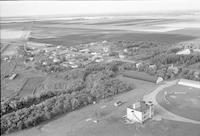
Title
-
Grandview
-
Description
-
Aerial photograph of Grandview, a rural community in the Parkland Region of Alberta.
-
Date
-
1956
-
-
Title
-
Ashville
-
Description
-
Aerial photograph of Ashville, a community in south-western Manitoba.
-
Date
-
1956
-
-
Title
-
Bagot
-
Description
-
Aerial photograph of Bagot, an unincorporated community in Manitoba.
-
Date
-
1956
-
-
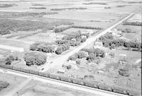
Title
-
Domain
-
Description
-
Aerial photograph of Domain, an unincorporated community in the south of Manitoba.
-
Date
-
1956
-
-
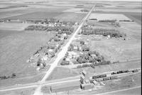
Title
-
Douglas
-
Description
-
Aerial photograph of Douglas, a settlement in western Manitoba.
-
Date
-
1956
-
-
Title
-
Douglas
-
Description
-
Aerial photograph of Douglas, a settlement in western Manitoba.
-
Date
-
1956
-
-
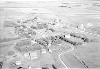
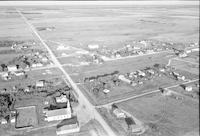
Title
-
Dropmore
-
Description
-
Aerial photograph of Dropmore, a community in the Parkland Region of Manitoba.
-
-
Title
-
Endcliffe
-
Description
-
Aerial photograph of Endcliffe, a community located on the Parkland Region of Manitoba.
-
-
Title
-
Gordon
-
Description
-
Aerial photograph of Gordon, a community in the Interlake Region of Manitoba, showing an elevator and farmland.
-
Date
-
1956
-
-
Title
-
Grandview
-
Description
-
Aerial photograph of Grandview, a rural community in the Parkland Region of Alberta.
-
-
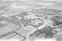
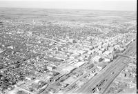
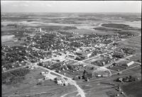
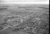
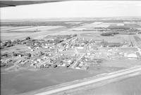
Title
-
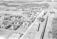
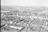
Brandon
-
Description
-
Aerial photograph of the former Brandon Mental Health Centre located in Brandon, Manitoba.
-
Date
-
1956
-
-
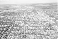
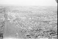
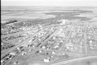
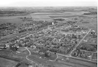
Title
-
Brandon
-
Description
-
Aerial photograph of Brandon, a city in western Manitoba.
-
Date
-
1956
-
-
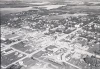
Title
-
Brandon
-
Description
-
Aerial photograph of Brandon, a city in western Manitoba.
-
Date
-
1956
-
-
Title
-
Brandon
-
Description
-
Aerial photograph of Brandon, a city in western Manitoba.
-
Date
-
1956
-
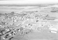
-
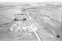
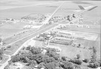
Title
-
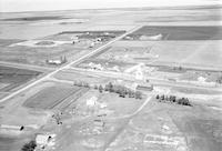
Contour
-
Description
-
Aerial photograph of Contour, a locality in eastern Manitoba, containing a grain elevator and surrounded by farmland.
-
-
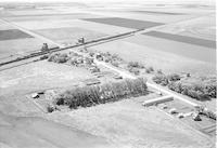
Title
-
Birnie
-
Description
-
Aerial photograph of Birnie, a community in the Westman Region of Manitoba.
-
Date
-
1956
-
-
Title
-
Deepdale
-
Description
-
Aerial photograph of Deepdale, a community in the Parkland Region of Manitoba.
-
Date
-
1956
-
-
Title
-
Dufrost
-
Description
-
Aerial photograph of Dufrost, a community in the eastern side of Manitoba.
-
Date
-
1956
-
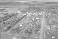
-
Title
-
Elie
-
Description
-
Aerial photograph of Elie, a local urban district in in the Central Plains Region of Manitoba.
-
Date
-
1956
-
-
Title
-
Elie
-
Description
-
Aerial photograph of Elie, a local urban district in in the Central Plains Region of Manitoba.
-
Date
-
1956
-
-
Title
-
Elva
-
Description
-
Aerial photograph of Elva, a community in south-western Manitoba.
-
Date
-
1956
-
-
Title
-
Gilbert Plains
-
Description
-
Aerial photograph of Gilbert Plains, an urban community in the Parkland Region of Manitoba.
-
Date
-
1956
-
-
Title
-
Gladstone
-
Description
-
Aerial photograph of Gladstone, an urban community in the Parkland Region of Manitoba that held town status prior to 2015.
-
-
Title
-
Gilbert Plains
-
Description
-
Aerial photograph of Gilbert Plains, an urban community in the Parkland Region of Manitoba.
-
Date
-
1956
-
-
Title
-
Grosse Isle
-
Description
-
Aerial photograph of Grosse Isle, a small rural community located between the Rural Municipality of Rosser and the Rural Municipality of Rockwood in Manitoba.
-
Date
-
1956
-
-
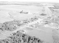
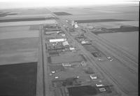
Title
-
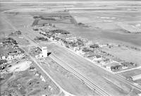
Hartney
-
Description
-
Aerial photograph of Hartney, a town in southwest Manitoba. Two grain elevators are visible in the center. An expanse of farmland is visible in the background.
-
Date
-
1958
-
-
Title
-
Hartney
-
Description
-
Aerial photograph of Hartney, a town in southwest Manitoba. An expanse of farmland is visible in the background.
-
Date
-
1958
-
-
Title
-
High Bluff
-
Description
-
Aerial photograph of High Bluff, a populated community in the Central Plains Region of Manitoba, containing one grain elevator. An expanse of farmland is visible in the background.
-
Date
-
1956
-
-
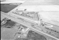
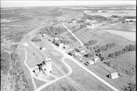
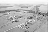
Title
-
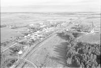
Howden
-
Description
-
Aerial photograph of a railroad siding in Howden, a hamlet in eastern Manitoba. An expanse of farmland is visible in the background.
-
Date
-
1956
-
-
Title
-
Letellier
-
Description
-
Aerial photograph of Letellier, a community in the Pembina Valley Region of Manitoba, containing multiple grain elevators. An expanse of farmland is visible in the background.
-
Date
-
1956
-
-
Title
-
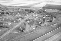
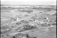
Kelwood
-
Description
-
Aerial photograph of Kelwood, a community in western Manitoba, containing a church and two grain elevators. Farmland is visible around the community.
-
Date
-
1956
-
-
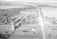
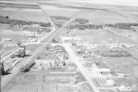
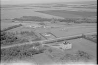
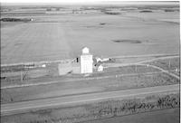
Title
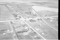
-
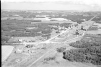
Keyes
-
Description
-
Aerial photograph of Keyes, a community in the Central Plains Region of Manitoba, including one grain elevator.
-
-
Title
-
La Salle
-
Description
-
Aerial photograph of La Salle, a town in the Winnipeg Capital Region of Manitoba, containing a grain elevator and the St. Hyacinthe Roman Catholic Church. An expanse of farmland is visible in the background.
-
Date
-
1956
-
-
Title
-
Laurier
-
Description
-
Aerial photograph of Laurier, a community in the Parkland Region of Manitoba, including one grain elevator. A church is visible in the foreground and an expanse of farmland is visible in the background.
-
Date
-
1956
-
-
Title
-
Letellier
-
Description
-
Aerial photograph of Letellier, a community in the Pembina Valley Region of Manitoba, containing multiple grain elevators. An expanse of farmland is visible in the background.
-
Date
-
1956
-
-
Title
-
Kelwood
-
Description
-
Aerial photograph of Kelwood, a community in western Manitoba. An expanse of farmland is visible in the background.
-
Date
-
1956
-
-
Title
-
Lauder
-
Description
-
Aerial photograph of Lauder, a small community in western Manitoba, including grain elevators. An expanse of farmland is visible in the background.
-
Date
-
1956
-
-
Title
-
Laurier
-
Description
-
Aerial photograph of Laurier, a community in the Parkland Region of Manitoba, including one grain elevator and a church. An expanse of farmland is visible in the background.
-
Date
-
1956
-
-
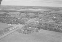
Title
-
Altona
-
Description
-
Aerial photograph of Altona, a town in southern Manitoba.
-
Date
-
1956
-

-
Title
-
Miami
-
Description
-
Aerial photograph of Miami, a community in the Pembina Valley Region of Manitoba.
-
Date
-
1957
-

-
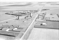
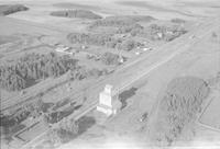
Title
-
Makaroff
-
Description
-
Aerial photograph of Makaroff, a community in the Parkland Region of Manitoba, including one grain elevator. An expanse of land is visible in the background.
-
Date
-
1956
Pages


