Error message
- Warning: count(): Parameter must be an array or an object that implements Countable in theme_pager_link() (line 637 of /opt/rh/httpd24/root/var/www/html/drupal/web/includes/pager.inc).
- Warning: count(): Parameter must be an array or an object that implements Countable in theme_pager_link() (line 637 of /opt/rh/httpd24/root/var/www/html/drupal/web/includes/pager.inc).
Search results
Pages
-
-
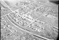
Title
-
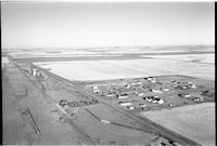
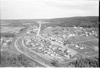
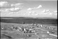
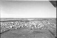
Paradise Hill
-
Description
-
Aerial photograph of the village of Paradise Hill, showing surrounding forested rolling hills.
-
-
Title
-
Superb
-
Description
-
Aerial photograph of a agricultural hamlet with an expanse of farmland in the background.
-
-
Title
-
Smiley
-
Description
-
Aerial photograph of an agricultural community surrounded by farmland and tree stands.
-
-
Title
-
Spuce Lake
-
Description
-
Aerial photograph of an agricultural hamlet surrounded by an expanse of farmland.
-
-
Title
-
Sovereign
-
Description
-
Aerial photograph of a hamlet surrounded by an expanse of farmland.
-
-
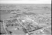
Title
-
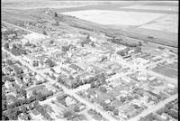
Spiritwood
-
Description
-
Aerial photograph of a large town surrounded by farmland.
-
-
Title
-
Senlac
-
Description
-
Aerial photograph of an agricultural village surrounded by an expanse of farmland.
-
-
Title
-
Sovereign
-
Description
-
Aerial photograph of a hamlet surrounded by an expanse of farmland.
-
-
Title
-
Wilkie
-
Description
-
Aerial photograph of small agricultural town surrounded by expansive farmland.
-

-
Title
-
Waseca
-
Description
-
Aerial photograph of an agricultural village surrounded by tree dotted farmland.
-
-
Title
-
Wilkie
-
Description
-
Aerial photograph of small agricultural town surrounded by expansive farmland.
-
-
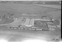
Title
-
Wilkie Hospital
-
Description
-
Aerial photograph of the Wilkie Union Hospital.
-
-
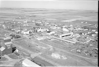
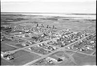
Title
-
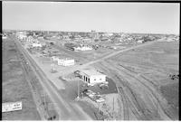
North Battleford
-
Description
-
Aerial photograph of small town with a water tank, hospital, school, churches and large Quonset. Houses and streets with agricultural land visible in the background.
-
-
Title
-
Paradise Hill
-
Description
-
Aerial photograph of the village of Paradise Hill, showing surrounding forested rolling hills and farmland.
-
-
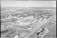
Title
-
North Battleford
-
Description
-
Aerial photograph of North Battleford. Managre's Garage and Service Station are visible in the foreground.
-

-
Title
-
Totnes
-
Description
-
Aerial photograph of a very small rural community. Surrounded by a vast expanse of farmland devoid of trees.
-
Date
-
, 1956
-

-
Title
-
Shell Lake
-
Description
-
Aerial photograph of a small agricultural village. An expanse of forest and farmland is visible in the background.
-

-
Title
-
Paradise Hill
-
Description
-
Aerial photograph of the village of Paradise Hill, showing surrounding forested rolling hills.
-
-
Title
-
Stranraer
-
Description
-
Aerial photograph of a small hamlet surrounded by a vast expanse of farmland.
-
-
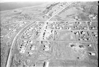
Title
-
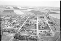
Luseland
-
Description
-
Aerial photograph of a small town with an expanse of farm land in the distance. Main Street, the curling rink, a large park, and a school are all easily visible.
-

-
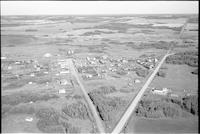
Title
-
Neilburg
-
Description
-
Aerial photograph of a small village. An expanse of farmland is visible in the background.
-
-
Title
-
Onion Lake
-
Description
-
Aerial photograph of a small community. An expanse of woodland and some farmland is visible in the background.
-
Date
-
, 1956
-

-
Title
-
Shell Lake
-
Description
-
Aerial photograph of a small agricultural community. The village is surrounded by forest and farmland.
-
-
Title
-
Unity
-
Description
-
Aerial photograph of a town with farmland in the background.
-

-
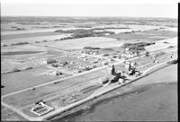
Title
-
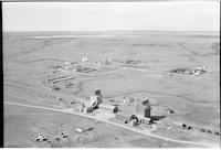
Southminster
-
Description
-
Aerial photograph of two grain elevators surrounded by an expanse of farmland. The foremost elevator is labelled: "Saskatchewan Pool No. 1096 Southminster B."
-
Date
-
, 1956
-
-
Title
-
Wilkie
-
Description
-
Aerial photograph of a town with farmland in the background.
-
Date
-
, 1955
-
-
Title
-
Paradise Hill
-
Description
-
Aerial photograph of the village of Paradise Hill, a lake and forested rolling hills.
-
-
Title
-
Unity
-
Description
-
Aerial photograph of an agricultural town.
-
Date
-
, 1953
-
-
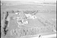
Title
-
Unity Hospital
-
Description
-
Aerial photograph of the hospital in the town of Unity, Saskatchewan.
-
-
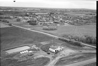
Title
-
Paynton: Service Station
-
Description
-
Aerial photograph of an agricultural village. "Petty's Esso Service" and "Imperial" service station is visible in the foreground.
-
Date
-
, 1956
-
-
Title
-
Maidstone
-
Description
-
Aerial photograph of a small town with a broad expanse of farm land in the distance. Grain elevators, main street, the school and the curling rink are the dominant features.
-
-
Title
-
Plenty
-
Description
-
Aerial photograph of a small village. An expanse of farmland is visible in the background.
-

-
Title
-
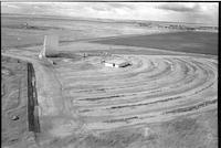
Spiritwood
-
Description
-
Aerial photograph of a town surrounded by farm land. The school is easily distinguishable, as are the rodeo grounds on the outskirts of town.
-
Date
-
, 1955
-
-
Title
-
Vawn
-
Description
-
Aerial photograph of an agricultural village surrounded by farmland interspersed with trees.
-
-
Title
-
Scott
-
Description
-
Aerial photograph of a small town. An expanse of farmland is visible in the background.
-
-
Title
-
Superb
-
Description
-
Aerial photograph of Hamlet surrounded by vast amounts of farmland.
-
-
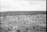
Title
-
Spiritwood
-
Description
-
Aerial photograph of a large town on the prairies.
-
-
Title
-
Wilkie
-
Description
-
Aerial photograph of the downtown area of a small agricultural town surrounded by farmland.
-
-
Title
-
Wilkie Drive-In Theatre
-
Description
-
Aerial photograph of the Wilkie drive-in theatre.
-

-
Title
-
North Battleford: Werb's Stockyard
-
Description
-
Aerial photograph of a stockyard. North Battleford is visible in the distance.
-
-
Title
-
Pinkham
-
Description
-
Aerial photograph of a small agricultural community. An expanse of farmland is visible in the background.
-
-
Title
-
North Battleford: Werb's Stockyard
-
Description
-
Aerial photograph of a stockyard.
-
-
Title
-
Paradise Hill
-
Description
-
Aerial photograph of Paradise Hill, showing the village's main street, church, grain elevators and dwellings. A railroad runs down the left side of the image and a portion of a lake is visible in the upper left-hand corner.
-

-
Title
-
Tramping Lake
-
Description
-
Aerial photograph of an agricultural village with farmland in the background.
-
-
Title
-
Vawn
-
Description
-
Aerial photograph of an agricultural village surrounded by farmland interspersed with trees.
-
-
Title
-
Spiritwood
-
Description
-
Aerial photograph of a town. Several grain elevators, the railroad, and the entryway to the rodeo grounds are visible.
-
-
Title
-
Paradise Hill
-
Description
-
Aerial photograph of Paradise Hill, showing the village's main street, church, and various other dwellings. A railroad runs from lower right to upper left of the photograph.
-

-
Title
-
Tramping Lake
-
Description
-
Aerial photograph of a village surrounded by an expanse of treeless farmland.
-

-
Title
-
Sovereign
-
Description
-
Aerial photograph of a hamlet.
-

-
Title
-
Vawn
-
Description
-
Aerial photograph of a agricultural village so farmland dotted with trees in the background.
Pages


