Error message
Warning: count(): Parameter must be an array or an object that implements Countable in theme_pager_link() (line 637 of /opt/rh/httpd24/root/var/www/html/drupal/web/includes/pager.inc).
Search results
Pages
-

-
Title
-
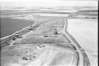
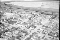
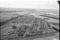
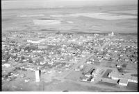
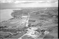
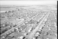
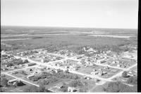
Pierceland
-
Description
-
Aerial photograph of an agricultural village in Saskatchewan. An expanse of farmland is visible in the background.
-
Date
-
, 1956
-

-
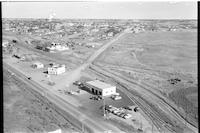
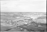
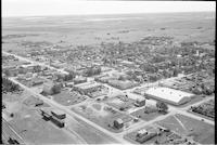
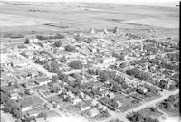
Title
-
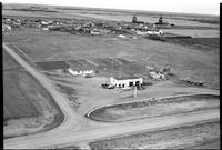
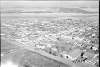
North Battleford
-
Description
-
Aerial photograph of a service station with a small city in the background. The service station is called "Townmann's Service Station."
-

-
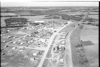
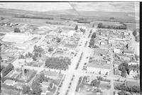
Title
-
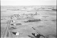
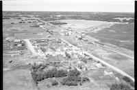
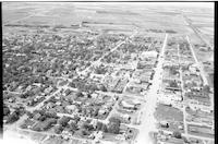
Neilburg
-
Description
-
Aerial photograph of a small town. The main street is lined with shops.
-
-
Title
-
North Battleford
-
Description
-
Aerial photograph of a service station with people walking on a road, a vehicle, and cattle and agricultural land visible in background.
-
Date
-
, 1955
-
-
Title
-
Glaslyn
-
Description
-
Aerial photograph of Dart's Store in a small village. The store is located at the junction of three roads, and the railroad runs nearby.
-
Date
-
, 1956
-
-
Title
-
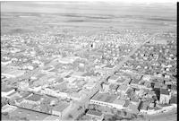
North Battleford
-
Description
-
Aerial photograph of a small town showing many storefronts, vehicles, hotels, and a water tank. Houses with agricultural land in background.
-

-
Title
-
North Battleford
-
Description
-
Aerial photograph of a small city. Two gas stations are in the foreground. The on the left says "Patron Oil Co. Ltd." and the one on the right says "North Star Oil."
-
-
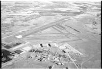
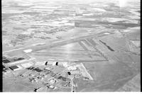
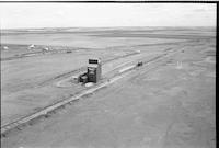
Title
-
North Battleford Airport
-
Description
-
Aerial photograph of the airport at North Battleford. An expanse of farmland is visible in the background.
-
Date
-
, 1959
-
-
Title
-
North Battleford Airport
-
Description
-
Aerial photograph of the airport at North Battleford. An expanse of farmland is visible in the background.
-
Date
-
, 1959
-

-
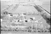
Title
-
North Battleford: Mental Hospital
-
Description
-
Aerial photograph of the Mental Hospital near North Battleford. The buildings are surrounded by planted trees, then farm land.
-
-
Title
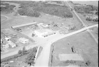
-
Glaslyn
-
Description
-
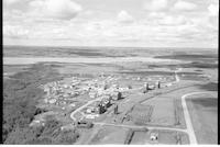
Aerial photograph of a village surrounded by farm land. The main street, railroad, grain elevators, and a school [?] are visible. Dart's Store is visible at the far end of the town, near the junction of three roads.
-
Date
-
, 1956
-
-
Title
-
North Battleford
-
Description
-
Aerial photograph of North Battleford. Manegre's garage is visible in the foreground.
-
-
Title
-
Glaslyn
-
Description
-
Aerial photograph of a village surrounded by farm land and forests. The view looks across the railroad to the town.
-
Date
-
, 1956
-
-
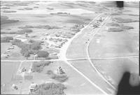
Title
-
Fairmount
-
Description
-
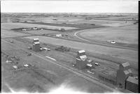
Aerial photograph of a hamlet with grain elevators, farmhouses and agricultural land visible in the background.a
-
-
Title
-
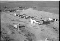
Paynton: Service Station
-
Description
-
Aerial photograph of an agricultural village in Saskatchewan. A "TEXACO" service station is visible in the foreground.
-
Date
-
, 1956
-

-
Title
-
Onion Lake
-
Description
-
Aerial photograph of a small community. An expanse of woodland and some farmland is visible in the background.
-
Date
-
, 1956
-
-
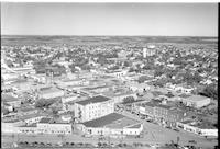
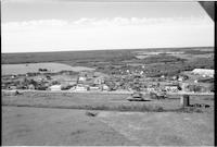
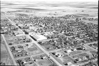
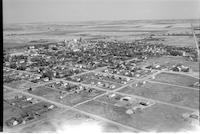
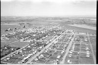
Title
-
North Battleford
-
Description
-
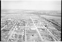
Aerial photograph of a small city.
-
-
Title
-
Fusilier
-
Description
-
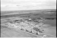
Aerial photograph of an unincorporated hamlet with a grain elevator, a church and houses with agricultural land in background.
-
-
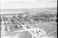
Title
-
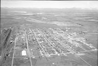
Wilkie
-
Description
-
Aerial photograph of downtown area of small agricultural town surrounded by expansive farmland.
-
![Beanfield [Beaufield]](/islandora/object/mcphail%3A1581/datastream/TN/view)
-
Title
-
Beanfield [Beaufield]
-
Description
-
Aerial photograph of a hamlet surrounded by farmland.
-
Date
-
, 1956
-
-
Title
-
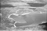
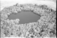
Attons Lake
-
Description
-
Aerial photograph of a lake surrounded by lightly-forested prairie.
-
Date
-
, 1960
-
-
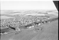
Title
-
Biggar
-
Description
-
Aerial photograph of a small town. Several grain elevators and a wide set of railway tracks are visible towards the left-hand side of the image, and farmland is visible in the background.
-
Date
-
, 1960
-
-
Title
-
Alticane
-
Description
-
Aerial photograph of a small town containing two grain elevators. An expanse of lightly wooded prairie is visible in the background.
-
-
Title
-
Unity
-
Description
-
Aerial photograph of a rural town surrounded by an expanse of farmland.
-
Date
-
, 1953
-
-
Title
-
Unity
-
Description
-
Aerial photograph of a pond and farmland.
-
Date
-
, 1953
-
-
Title
-
Wilkie
-
Description
-
Aerial photograph of small agricultural town surrounded by expansive farmland.
-
-
Title
-
Unity
-
Description
-
Aerial photograph of an agricultural town with an expanse of farmland in the background.
-
Date
-
, 1953
-

-
Title
-
Unity
-
Description
-
Aerial photograph of a small town surrounded by a vast expanse of farmland dotted with trees.
-
Date
-
, 1953
-
-
Title
-
Whitepool
-
Description
-
Aerial photograph of the White Pool grain elevator.
-
-
Title
-
Waseca
-
Description
-
Aerial photograph of a village with tree dotted farmland .
-
-
Title
-
Wilkie
-
Description
-
Aerial photograph of the downtown area of a small agricultural town surrounded by farmland.
-
-
Title
-
Unity Hospital
-
Description
-
Aerial photograph of the hospital in Unity, Saskatchewan.
-
-
Title
-
Kerrobert
-
Description
-
Aerial photograph of a small town. A grain elevator and an expanse of farmland are visible in the background.
-
Date
-
, 1959
-
-
Title
-
Wilkie
-
Description
-
Aerial photograph of downtown Wilkie, Saskatchewan, most prominently featuring Main Street.
-
-
Title
-
Wilkie
-
Description
-
Aerial photograph of small agricultural town surrounded by expansive farmland.
-
-
Title
-
Wilkie
-
Description
-
Aerial photograph of small agricultural town surrounded by expansive farmland.
-
-
Title
-
Wilbert
-
Description
-
Aerial photograph of three grain elevators next to railroad tracks. An expanse of mixed farmland / wooded prairie is visible in the background.
-
-
Title
-
Marsden
-
Description
-
Aerial photograph of a small town containing several grain elevators. A lake is visible in the background.
-
Date
-
, 1960
-
-
Title
-
Kerrobert
-
Description
-
Aerial photograph of a small town with two grain elevators. An expanse of farmland is visible in the background.
-
Date
-
, 1960
-
-
Title
-
Neilburg
-
Description
-
Aerial photograph of a small town containing several grain elevators which is surrounded by farmland.
-
Date
-
, 1960
-
-
Title
-
Cochin
-
Description
-
Aerial photograph of a small town next to a lake. An expanse of lightly forested prairie is visible in the background.
-
Date
-
, 1960
-
-
Title
-
Unity
-
Description
-
Aerial photograph of a small town containing several grain elevators. An expanse of farmland is visible in the background.
-
Date
-
, 1960
-
-
Title
-
Whitkow
-
Description
-
Aerial photograph of an agricultural hamlet. An expanse of lightly wooded prairie and farmland is visible in the background.
-
-
Title
-
Wilkie
-
Description
-
Aerial photograph of small agricultural town surrounded by expansive farmland. Shows the construction of the St. James Catholic Church.
-
-
Title
-
Unity
-
Description
-
Aerial photograph of a rural town with a vast expanse of farmland in the background.
-
Date
-
, 1953
-
-
Title
-
Unity
-
Description
-
Aerial photograph of an agricultural town surrounded by cropland.
-
Date
-
, 1953
-
-
Title
-
Wilkie
-
Description
-
Aerial photograph of downtown area of small agricultural town surrounded by expansive farmland.
-
-
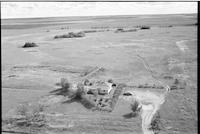
Title
-
Wilkie
-
Description
-
Aerial photograph of a single farm house surrounded by expansive prairie land.
-
-
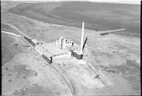
Title
-
Unity Salt Plant
-
Description
-
Aerial photograph of the salt plant in the town of Unity, Saskatchewan.
-
-
Title
-
Pierceland
-
Description
-
Aerial photograph of a small town. An expanse of forest and farmland lies behind it.
-
Date
-
, 1959
Pages


