Error message
Warning: count(): Parameter must be an array or an object that implements Countable in theme_pager_link() (line 637 of /opt/rh/httpd24/root/var/www/html/drupal/web/includes/pager.inc).
Search results
Pages
-
-
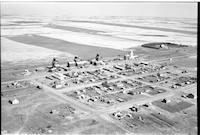
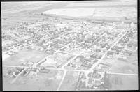
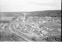
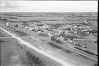
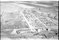
Title
-
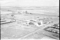
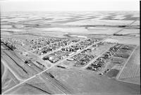
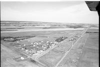
Simmie
-
Description
-
Aerial photograph of a hamlet with expansive farmland in the background.
-
-
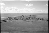
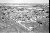
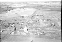
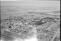
Title
-
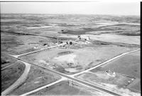
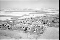
Sovereign
-
Description
-
Aerial photograph of a hamlet surrounded by an expanse of farmland.
-
-
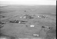
Title
-
Expanse
-
Description
-
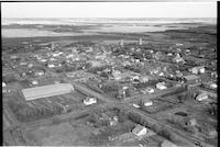
Aerial photograph of an unincorporated area near a body of water.
-
Date
-
, 1956
-
-
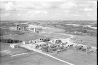
Title
-
West Bend
-
Description
-
Aerial photograph of hamlet with a vast expanse of tree dotted farmland in the background.
-
-
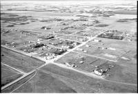
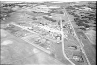
Title
-
Wilkie
-
Description
-
Aerial photograph of small agricultural town surrounded by expansive farmland.
-

-
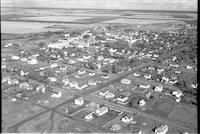
Title
-
Waseca
-
Description
-
Aerial photograph of an agricultural village surrounded by tree dotted farmland.
-
-
Title
-
Wakaw
-
Description
-
Aerial photograph of a village surrounded by farmland.
-
-
Title
-
Warman
-
Description
-
Aerial photograph of a village surrounded by tree dotted farmland.
-
-
Title
-
Wilkie
-
Description
-
Aerial photograph of small agricultural town surrounded by expansive farmland.
-
-
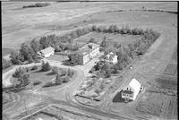
Title
-
Wilkie Hospital
-
Description
-
Aerial photograph of the Wilkie Union Hospital.
-
-
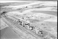
Title
-
Kisby
-
Description
-
Aerial photograph of a small town with grain elevators, railway tracks, church, school, agricultural land.
-
Date
-
, 1955
-
-
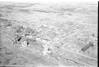
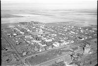
Title
-
North Battleford
-
Description
-
Aerial photograph of small town with a water tank, hospital, school, churches and large Quonset. Houses and streets with agricultural land visible in the background.
-
-
Title
-
Gouverneur
-
Description
-
Aerial photograph of 3 grain elevators, farmhouses, access roads, barns and agricultural land.
-
-
Title
-
Paradise Hill
-
Description
-
Aerial photograph of the village of Paradise Hill, showing surrounding forested rolling hills and farmland.
-
-
Title
-
Pense
-
Description
-
Aerial photograph of an agricultural village. An expanse of farmland is visible in the background.
-
-
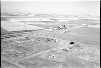
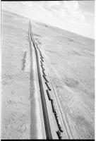
Title
-
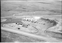
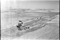
pipeline: Trans Canada 18 miles south of Lancer
-
Description
-
Aerial photograph of the construction of the Trans Canada pipeline, 18 miles south of Lancer.
-
Date
-
, 1956
-
-
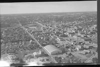
Title
-
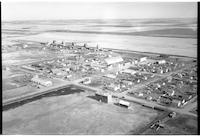
North Battleford
-
Description
-
Aerial photograph of North Battleford. Managre's Garage and Service Station are visible in the foreground.
-

-
Title
-
Penzance
-
Description
-
Aerial photograph of an agricultural village. An expanse of farmland is visible in the background.
-

-
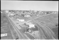
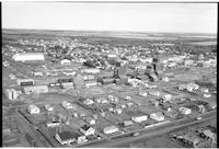
Title
-
Swift Current
-
Description
-
Aerial photograph of a small city with a bridge over the railway. In the foreground is an experimental farm.
-
Date
-
, 1955
-
-
Title
-
Tuberose
-
Description
-
Aerial photograph of a hamlet surrounded by a vast expanse of farmland.
-
Date
-
, 1956
-
-
Title
-
Valjean
-
Description
-
Aerial photograph of a hamlet surrounded by rolling hills of farmland.
-

-
Title
-
Totnes
-
Description
-
Aerial photograph of a very small rural community. Surrounded by a vast expanse of farmland devoid of trees.
-
Date
-
, 1956
-
-
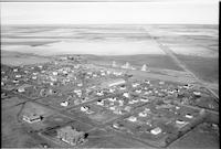
Title
-
Simpson
-
Description
-
Aerial photograph of an agricultural village. An expanse of farmland is visible in the background.
-
-
Title
-
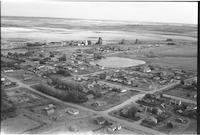
Shellbrook
-
Description
-
Aerial photograph of a well-sized rural community. An expanse of farmland is visible in the background.
-
-
Title
-
Springside
-
Description
-
Aerial photograph of an agricultural village on the Prairies.
-
-
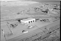
Title
-
North Star Oil: service station
-
Description
-
Aerial photograph of North Star Oil service station. There are numerous vehicles parks nearby the service station.
-
-
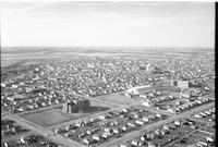
Title
-
Weyburn
-
Description
-
Aerial photograph of a small city. Farm land stretches into the distance. In the upper part of the picture, the Weyburn Mental Hospital, later called the Souris Valley Mental Health Hospital and the Souris Valley Extended Care Centre, is visible, as is the courthouse.
-
Date
-
, 1955
-
-
Title
-
Stoughton
-
Description
-
Aerial photograph of an agricultural community surrounded by farmland.
-
Date
-
, 1955
-
-
Title
-
Star City
-
Description
-
Aerial photograph of a large town in Saskatchewan.
-
Date
-
, 1955
-
-
Title
-
Vanguard
-
Description
-
Aerial photograph of a village surrounded by farm land. Main street, the railroad, and grain elevators are the most visible features.
-
-
Title
-
Swift Current
-
Description
-
Aerial photograph of a small city in southern Saskatchewan. An expanse of farmland is visible in the background.
-
-
Title
-
Esso Service Station
-
Description
-
Aerial photograph of the Esso Service Station in Swift Current, Saskatchewan.
-
-
Title
-
Struan
-
Description
-
Aerial photograph of small town surrounded by farmland dotted with trees.
-
-
Title
-
Wyatt
-
Description
-
Aerial photograph of a small community with expansive farmland in the background.
-
-
Title
-
Vanguard
-
Description
-
Aerial photograph of a village surrounded by farm land. Main street, the railroad, grain elevators, and a quonset dominate the scene.
-
-
Title
-
Tompkins
-
Description
-
Aerial photograph of a village with farm land beyond the town. Grain elevators, the railroad, and a hotel are clearly visible.
-

-
Title
-
Tompkins
-
Description
-
Aerial photograph of a village with a large church in the foreground.
-

-
Title
-
Shell Lake
-
Description
-
Aerial photograph of a small agricultural village. An expanse of forest and farmland is visible in the background.
-
-
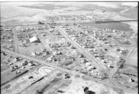
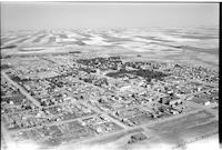
Title
-
Tisdale
-
Description
-
Aerial photograph of a large agricultural town and business center. An expanse of farmland is visible in the background.
-
-
Title
-
Sedley
-
Description
-
Aerial photograph of a small village surrounded by farmland.
-
-
Title
-
Shaunavon
-
Description
-
Aerial photograph of a town with a checkerboard of farmland in the background.
-
-
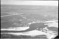
Title
-
Stony Rapids
-
Description
-
Aerial photograph of a northern hamlet adjacent to the Fond du Lac River.
-
-
Title
-
Verwood
-
Description
-
Aerial photograph of a hamlet with a large church in the background.
-
Date
-
, 1955
-
-
Title
-
Wilmar
-
Description
-
Aerial photograph of an unincorporated hamlet surrounded by farmland, the landscape dotted with clusters of trees. The shadow of an airplane can be seen at the bottom of the photograph.
-
Date
-
, 1955
-
-
Title
-
Willows
-
Description
-
Aerial photograph of a hamlet sloping down towards a valley.
-
Date
-
, 1955
-

-
Title
-
Paradise Hill
-
Description
-
Aerial photograph of the village of Paradise Hill, showing surrounding forested rolling hills.
-
-
Title
-
Sonningdale
-
Description
-
Aerial photograph of an agricultural hamlet surrounded by farmland.
-

-
Title
-
Sclanders
-
Description
-
Aerial photograph of two grain elevators within the small community of Sclanders, Saskatchewan.
-
-
Title
-
Shaunavon
-
Description
-
Aerial photograph of a town. The upper half of the picture is farm land.
-
-
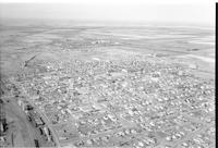
Title
-
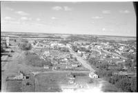
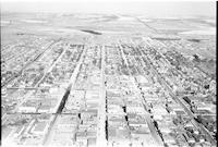
Prince Albert
-
Description
-
Aerial photograph of a city.
Pages


