Error message
Warning: count(): Parameter must be an array or an object that implements Countable in theme_pager_link() (line 637 of /opt/rh/httpd24/root/var/www/html/drupal/web/includes/pager.inc).
Search results
Pages
-
-
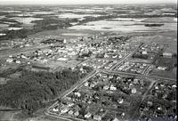
Title
-
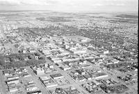
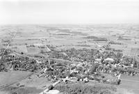
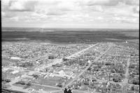
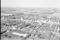
Lethbridge
-
Description
-
Aerial photograph of Lethbridge, a city in Southern Alberta.
-
Date
-
1956
-
-
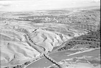
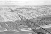
Title
-
Lethbridge
-
Description
-
Aerial photograph of Lethbridge, a city in Southern Alberta. The Oldman River is visible in the foreground. The Lethbridge Viaduct is visible to the right.
-
Date
-
1956
-
-
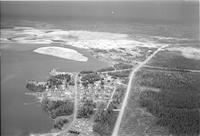
Title
-
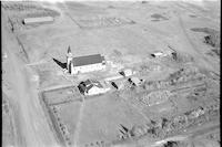
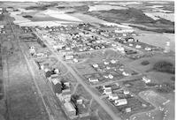
Jackfish Lake
-
Description
-
Aerial photograph of a church in Jackfish, a hamlet in Saskatchewan. A cemetery is visible in the background.
-
-
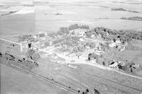
Title
-
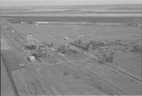
Kathryn
-
Description
-
Aerial photograph of Kathryn, a hamlet in Southern Alberta, containing two grain elevators. An expanse of farmland is visible in the background.
-
Date
-
1956
-
-
Title
-
Kelwood
-
Description
-
Aerial photograph of Kelwood, a community in western Manitoba. An expanse of farmland is visible in the background.
-
Date
-
1956
-
-
Title
-
Lafond
-
Description
-
Aerial photograph of Lafond, a hamlet in Northern Alberta.
-
Date
-
1957-07
-
-
Title
-
Lac La Biche
-
Description
-
Aerial photograph of Lac La Biche, a hamlet in Northern Alberta.
-
Date
-
1956
-
-
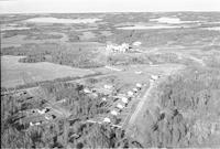
Title
-
Lanfine
-
Description
-
Aerial photograph of Lanfine, a locality in Central Alberta, containing two grain elevators.
-
Date
-
1956
-
-
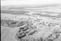
Title
-
Lauder
-
Description
-
Aerial photograph of Lauder, a small community in western Manitoba, including grain elevators. An expanse of farmland is visible in the background.
-
Date
-
1956
-
-
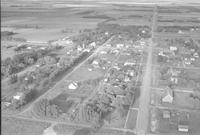
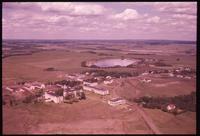
Title
-
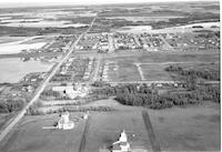
Laurier
-
Description
-
Aerial photograph of Laurier, a community in the Parkland Region of Manitoba, including one grain elevator and a church. An expanse of farmland is visible in the background.
-
Date
-
1956
-

-
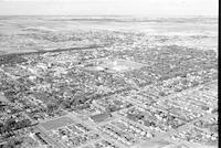
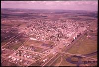
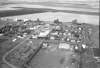
Title
-
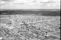
Lethbridge
-
Description
-
Aerial photograph of Lethbridge, a city in Southern Alberta. An expanse of land is visible in the background.
-
Date
-
1956
-
-
Title
-
Lethbridge
-
Description
-
Aerial photograph of the High Level Bridge in Lethbridge, Alberta. The city is visible in the background.
-
Date
-
1956
-
-
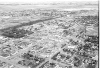
Title
-
Lethbridge
-
Description
-
Aerial photograph of Lethbridge, a city in Southern Alberta.
-
Date
-
1956
-
-
Title
-
Lethbridge
-
Description
-
Aerial photograph of Lethbridge, a city in Southern Alberta.
-
Date
-
1956
-
-
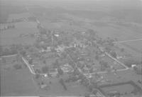
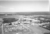
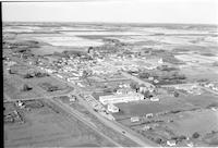
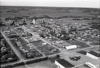
Title
-
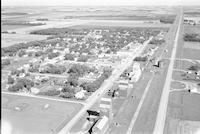
Ponoka
-
Description
-
Aerial photograph of Ponoka, a town in Central Alberta.
-
Date
-
1959
-
-
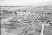
Title
-
Ponoka
-
Description
-
Aerial photograph of Ponoka, a town in Central Alberta.
-
Date
-
1959
-
-
Title
-
Little Long Lac
-
Description
-
Aerial photograph of Little Long Lac, Ontario.
-
Date
-
1958
-
-
Title
-
Palmerston
-
Description
-
Aerial photograph of Palmerston, an unincorporated community in the town of Minto, Alberta.
-
Date
-
1958
-
-
Title
-
Hillsdale
-
Description
-
Aerial photograph of Hillsdale, a community within the township of Springwater in Ontario.
-
Date
-
1958
-
-
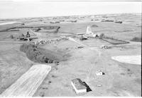
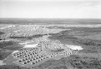
Title
-
Grand Centre
-
Description
-
Aerial photograph of Grand Centre, a former town in Central Alberta, now known as Cold Lake South.
-
Date
-
1959
-
-
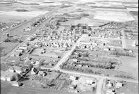
Title
-
Ponoka
-
Description
-
Aerial photograph of Ponoka, a town in Central Alberta.
-
Date
-
1959
-
-
Title
-
Grand Centre
-
Description
-
Aerial photograph of Grand Centre, a former town in Central Alberta, now known as Cold Lake South.
-
Date
-
1959
-
-
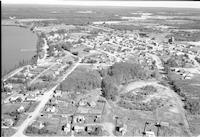
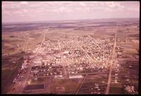
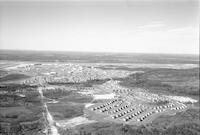
Title
-
Cold Lake
-
Description
-
Aerial photograph of Cold Lake, a former town (now city) in Central Alberta.
-
Date
-
1959
-
-
Title
-
Cold Lake
-
Description
-
Aerial photograph of Cold Lake, a former town (now city) in Central Alberta.
-
Date
-
1959
-
-
Title
-
Provost
-
Description
-
Aerial photograph of Provost, a town in Central Alberta.
-
Date
-
1959
-
-
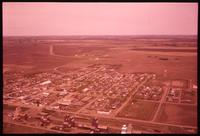
Title
-
Andrew
-
Description
-
Aerial photograph of Andrew, a village in Central Alberta.
-
Date
-
1956
-
-
Title
-
Andrew
-
Description
-
Aerial photograph of Andrew, a village in Central Alberta.
-
Date
-
1956
-
-
Title
-
Andrew
-
Description
-
Aerial photograph of Andrew, a village in Central Alberta.
-
Date
-
1656
-
-
Title
-
Andrew
-
Description
-
Aerial photograph of Andrew, a village in Central Alberta.
-
Date
-
1956
-
-
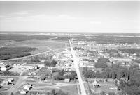
Title
-
Wainwright
-
Description
-
Aerial photograph of Wainwright, a town in Central Alberta.
-
Date
-
1959
-
-
Title
-
Wainwright
-
Description
-
Aerial photograph of Wainwright, a town on Central Alberta.
-
Date
-
1959
-
-
Title
-
Allingham
-
Description
-
Aerial photograph of Allingham, a locality in Southern Alberta.
-
Date
-
1956
-
-
Title
-
Andrew
-
Description
-
Aerial photograph of Andrew, a village in Central Alberta.
-
Date
-
1956
-
-
Title
-
Arden
-
Description
-
Aerial photograph of Arden in Southwest Saskatchewan.
-
Date
-
1956
-
-
Title
-
Arden
-
Description
-
Aerial photograph of Arden, a town in Southwest Saskatchewan.
-
Date
-
1956
-
-
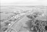
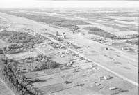
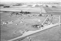
Title
-
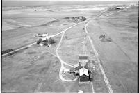
Lindbergh
-
Description
-
Aerial photograph of Lindbergh, a hamlet in Northern Alberta, including a grain elevator along the railroad. An expanse of farmland is visible in the bottom left corner.
-
Date
-
1956
-

-
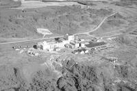
Title
-
Lindbergh
-
Description
-
Aerial photograph of the Canadian Salt Company plant in Lindbergh, Alberta.
-
Date
-
1957-08
-
-
Title
-
Lindbergh
-
Description
-
Aerial photograph of the Canadian Salt Company plant in Lindbergh, Alberta.
-
-
Title
-
Lindbergh
-
Description
-
Aerial photograph of Lindbergh, a hamlet in Northern Alberta. The Canadian Salt Company plant is visible.
-
-
Title
-
Mannville
-
Description
-
Aerial photograph of Mannville, a village in Central Alberta, containing several grain elevators.
-
Date
-
195-
-
-
Title
-
Mayerthorpe
-
Description
-
Aerial photograph of Mayerthorpe, a town in Central Alberta containing houses, barns, trees, a church, an several grain elevators.
-
-
Title
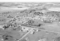
-
Monarch
-
Description
-
Aerial photograph of Monarch, a hamlet in Southern Alberta. An expanse of farmland is visible in the background.
-
Date
-
1956
-
-
Title
-
Altona
-
Description
-
Aerial photograph of Altona, a town in southern Manitoba.
-
Date
-
1956
-

-
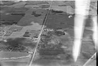
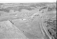
Title
-
Munson
-
Description
-
Aerial photograph of Munson, a village in Central Alberta. An expanse of farmland is visible in the background.
-
Date
-
1956
-
-
Title
-
Myrnam
-
Description
-
Aerial photograph of Myrnam, a village in Central Alberta.
-
Date
-
1956
-
-
Title
-
Myrnam
-
Description
-
Aerial photograph of Myrnam, a village in Central Alberta.
-
Date
-
1956
-

-
Title
-
Myrnam
-
Description
-
Aerial photograph of Myrnam, a village in Central Alberta.
-
Date
-
1956
-
-
Title
-
Miami
-
Description
-
Aerial photograph of Miami, a community in the Pembina Valley Region of Manitoba.
-
Date
-
1957
-

-
Title
-
Miami
-
Description
-
Aerial photograph of Miami, a community in the Pembina Valley Region of Manitoba.
-
Date
-
1957
-
-
Title
-
Morrin
-
Description
-
Aerial photograph of Morrin, a village in Central Alberta, containing several grain elevators. An expanse of farmland is visible in the background.
-
Date
-
1956
Pages


