Error message
- Warning: count(): Parameter must be an array or an object that implements Countable in theme_pager_link() (line 637 of /opt/rh/httpd24/root/var/www/html/drupal/web/includes/pager.inc).
- Warning: count(): Parameter must be an array or an object that implements Countable in theme_pager_link() (line 637 of /opt/rh/httpd24/root/var/www/html/drupal/web/includes/pager.inc).
- Warning: count(): Parameter must be an array or an object that implements Countable in theme_pager_link() (line 637 of /opt/rh/httpd24/root/var/www/html/drupal/web/includes/pager.inc).
Search results
Pages
-
-
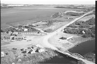
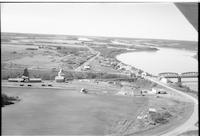
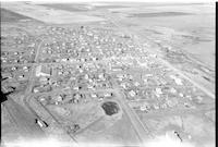
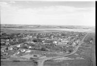
Title
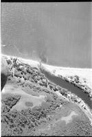
-
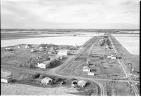
Cochin
-
Description
-
Aerial photograph of a resort village. Jackfish Lake Narrows Bridge spans Lehman Creek, a channel that connects Jackfish Lake and Murray Lake.
-
-
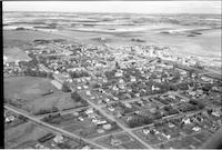
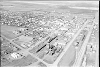
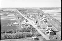
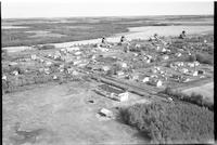
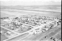
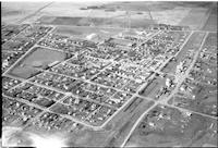
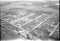
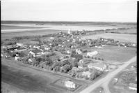
Title
-
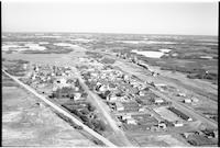
Rosthern
-
Description
-
Aerial photograph of a small town. An expanse of farmland is visible in the background.
-
Date
-
, 1955
-
-
Title
-
Prud'homme
-
Description
-
Aerial photograph of an agricultural village.
-
Date
-
, 1955
-
-
Title
-
Rouleau
-
Description
-
Aerial photograph of a small town. An expanse of farmland is visible in the background.
-
Date
-
, 1956
-
-
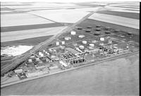
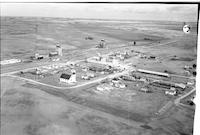
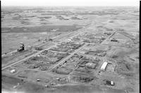
Title
-
Regina Co-op Refinery
-
Description
-
Aerial photograph of the Co-op Refinery in Regina. An expanse of farmland is visible in the background.
-
-
Title
-
Cochin
-
Description
-
Aerial photograph of a resort village. Jackfish Lake Narrows Bridge spans Lehman Creek, a channel that connects Jackfish Lake and Murray Lake.
-
-
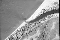
Title
-
Cochin
-
Description
-
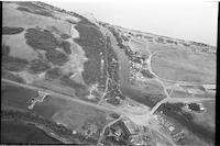
Aerial photograph of a resort village. A boat is on the lake, either Jackfish or Murray. A series of houses are along Lehman Creek, a channel that connects Jackfish Lake and Murray Lake.
-
-
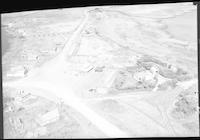
Title
-
Sask Power plant
-
Description
-
Aerial photograph of the Sask Power plant alongside Spadina Crescent under construction. The power plant is known today as the Queen Elizabeth Power Station operated by SaskPower. The South Saskatchewan River and the Grand Trunk train bridge is visible in the background.
-
-
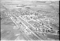
Title
-
Rosetown
-
Description
-
Aerial photograph of a large town. An expanse of farmland is visible in the background.
-
Date
-
, 1956
-
-
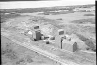
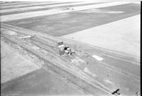
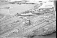
Title
-
Rex
-
Description
-
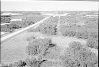
Aerial photograph of two grain elevators next to a railroad. An expanse of wooded prairie and farmland is visible in the background.
-
Date
-
, 1956
-
-
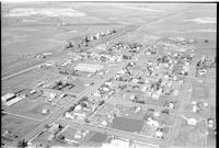
Title
-
Bruno
-
Description
-
Aerial photograph of a small town with churches, grain elevators schools, dwellings and agricultural land in background
-
-
Title
-
Sask Power power lines
-
Description
-
Aerial photograph of Sask Power power lines. An expanse of dense forest surrounds the trail of power lines.
-
-
Title
-
Sask Power power lines
-
Description
-
Aerial photograph of Sask Power power lines. An expanse of dense forest surrounds the trail of pipeline.
-
-
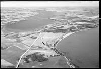
Title
-
Cochin
-
Description
-
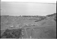
Aerial photograph of an incorporated resort village with Jackfish Lake in the background.
-
-
Title
-
Cochin
-
Description
-
Aerial photograph of a resort village. Jackfish Lake Narrows Bridge spans Lehman Creek, a channel that connects Jackfish Lake and Murray Lake.
-
-
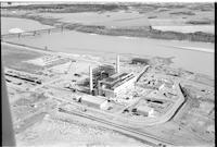
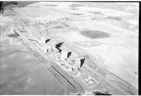
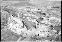
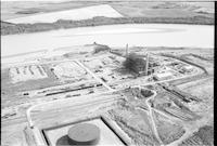
Title
-
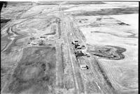
Estevan
-
Description
-
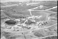
Aerial photograph of a power plant near Estevan. A winding body of water, most likely Long Creek, and farmland are visible.
-
-
Title
-
Beatty
-
Description
-
Aerial photograph of a village, small town with 5 grain elevators, a church, railroad tracks, a highway and agricultural land.
-
Date
-
, 1955
-
-
Title
-
Armilla
-
Description
-
Aerial photograph of Armilla grain elevators, train tracks a farm truck and cattle chute with agricultural and croplands visible in the background.
-
Date
-
, 1955
-
![Cochin [farms]](/islandora/object/mcphail%3A853/datastream/TN/view)
-
Title
-
Cochin [farms]
-
Description
-
Aerial photograph of an unidentified farm.
-
-
Title
-
Corning
-
Description
-
Aerial photograph of a small hamlet with a railway, railway station, grain elevators, church and dwellings. An expanse of Agricultural land visible in the background.g
-
-
Title
-
Cymric
-
Description
-
Aerial photograph of a small village with a few dwellings, grain elevators, rail way tracks with agricultural land in background.
-
-
Title
-
Ruthilda
-
Description
-
Aerial photograph of an agricultural village. An expanse of farmland is visible in the background.
-

-
Title
-
Ridgedale
-
Description
-
Aerial photograph of a village. An expanse of farmland is visible in the background.
-
-
Title
-
Ridgedale
-
Description
-
Aerial photograph of a village. An expanse of wooded prairie and farmland is visible in the background.
-
-
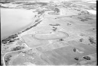
Title
-
Cochin
-
Description
-
Aerial photograph of a resort village. Jackfish Lake and Lehman Creek are visible.
-
-
Title
-
Deveron
-
Description
-
Aerial photograph of small Hamlet with grain elevators, train tracks, cattle corral, farmhouses and agricultural land visible in background.
-
Date
-
, 1955
-
-
Title
-
Richmound
-
Description
-
Aerial photograph of a village. An expanse of farmland is visible in the background.
-
Date
-
, 1956
-
-
Title
-
Estevan
-
Description
-
Aerial photograph of a power plant near Estevan.
-
-
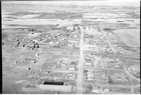
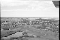
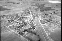
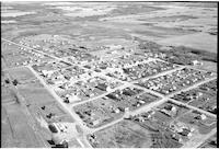
Title
-
Radisson
-
Description
-
Aerial photograph of a small town. An expanse of farmland is visible in the background.
-
-
Title
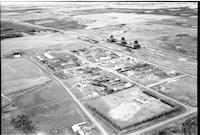
-
Borden
-
Description
-
Aerial photograph of a small town with dwellings, barns, access roads, highway, lumber yard, grain elevators, railway tracks and cropland in the background.
-
-
Title
-
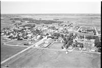
Rosthern
-
Description
-
Aerial photograph of a small town.
-
-
Title
-
Blaine Lake
-
Description
-
Aerial photograph of a small town with grain elevators , railway tracks, churches, and cropland visible in background.
-
-
Title
-
Sask Power plant
-
Description
-
Aerial photograph of the Sask Power plant along Spadina Crescent under construction. The power plant is known today as the Queen Elizabeth Power Station operated by SaskPower. The South Saskatchewan River is visible in the background.
-
-
Title
-
St. Walburg
-
Description
-
Aerial photograph of an agricultural town surrounded by farmland and wooded prairie.
-
-
Title
-
Reynaud
-
Description
-
Aerial photograph of a small agricultural community. An expanse of farmland is visible in the background.
-

-
Title
-
Rosthern
-
Description
-
Aerial photograph of a small town. An expanse of farmland is visible in the background.
-
Date
-
, 1955
-
-
Title
-
Quinton
-
Description
-
Aerial photograph of an agricultural village. An expanse of lightly wooded prairie and farmland is visible in the background.
-
-
Title
-
Bemersyde
-
Description
-
Aerial photograph of grain elevators, railroad tracks. rail fence and a couple of farmhouses with cropland in the background.
-

-
Title
-
St. Hippolyte Church
-
Description
-
Aerial photograph of St. Hippolyte Roman Catholic Church west of Vawn, Saskatchewan. The church is surrounded by homes and agricultural structures. Farmland and wooded prairie is visible in the background.
-
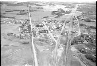
-
Title
-
Radisson
-
Description
-
Aerial photograph of a small village. An expanse of farmland is visible in the background.
-
-
Title
-
Salter
-
Description
-
Aerial photograph of two grain elevators beside a railroad in the middle of agricultural land.
-
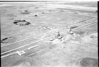
-
Title
-
Cochin
-
Description
-
Aerial photograph of the sports grounds and race track.
-
-
Title
-
St. Walburg
-
Description
-
Aerial photograph of an agricultural town surrounded by farmland and lightly wooded prairie.
-
-
Title
-
St. Louis
-
Description
-
Aerial photograph of an agricultural village beside the South Saskatchewan River. The St. Louis Bridge can be seen crossing the river, as well as an expanse of farmland in the background.
-
-
Title
-
Carlyle
-
Description
-
Aerial photograph of a small town. Farmland is visible in the background. Railway tracks and a dugout water reservoir are in the foreground.
-
Date
-
, 1955
-
-
Title
-
Benson
-
Description
-
Aerial photograph of a small hamlet with grain elevators, railway, corral, a church and agricultural land visible in backgraound.
-
Date
-
, 1955
-
-
Title
-
Cochin
-
Description
-
Aerial photograph of a resort village.
-
-
Title
-
Codette
-
Description
-
Aerial photograph of a small village with grain elevators, a church, several large buildings and agricultural land and a highway in background.
-

-
Title
-
St. Hippolyte Church
-
Description
-
Aerial photograph of St. Hippolyte Roman Catholic Church west of Vawn, Saskatchewan. The church is surrounded by farmland.
-
-
Title
-
Bruno
-
Description
-
Aerial photograph of a small town with dwellings, churches with agricultural land visible in the background.
Pages


