Error message
Warning: count(): Parameter must be an array or an object that implements Countable in theme_pager_link() (line 637 of /opt/rh/httpd24/root/var/www/html/drupal/web/includes/pager.inc).
Search results
Pages
-
-
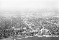
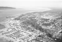
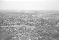
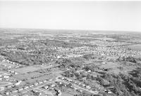
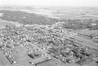
Title
-
Burlington
-
Description
-
Aerial photograph of Burlington, a city in Southern Ontario. Lake Ontario is visible in the foreground.
-
Date
-
1958
-
-
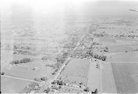
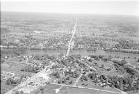
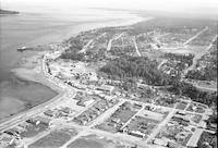
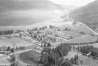
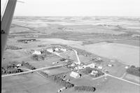
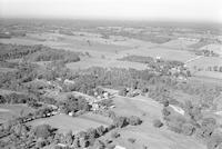
Title
-
Burtch or Mt. Pleasant
-
Description
-
Aerial photograph of a community in the County of Brant, Southern Ontario. A wing of the airplane is visible in the upper right side of the image.
-
Date
-
1958
-

-
Title
-
Copper Cliff
-
Description
-
Aerial photograph of the Copper Cliff South Mine in Northern Ontario.
-
-
Title
-
Copper Cliff
-
Description
-
Aerial photograph of the Copper Cliff South Mine in Northern Ontario.
-
-
Title
-
Cache Bay
-
Description
-
Aerial photograph of Cache Bay, a community in West Nipissing, Ontario.
-
Date
-
1958
-
-
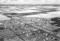
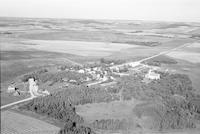
Title
-
Clearwater
-
Description
-
Aerial photograph of Clearwater, a community in south central Manitoba.
-
Date
-
1957
-
-
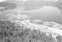
Title
-
Campbell River
-
Description
-
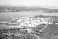
Aerial photograph of a lumber mill in Campbell River, British Columbia.
-
Date
-
1958
-

-
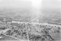
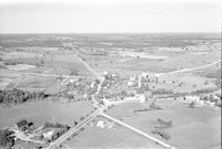
Title
-
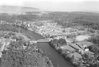
Caledonia
-
Description
-
Aerial photograph of Caledonia, a community located on the Grand River in Hadimand County, Ontario.
-
Date
-
1958
-
-
Title
-
Caledonia
-
Description
-
Aerial photograph of Caledonia, a community located on the Grand River in Hadimand County, Ontario.
-
Date
-
1958
-
-
Title
-
Caledonia
-
Description
-
Aerial photograph of Caledonia, a community located on the Grand River in Hadimand County, Ontario.
-
Date
-
1958
-
-
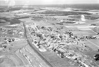
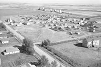
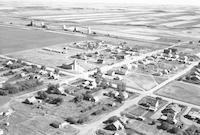
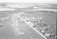
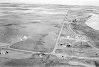
Title
-
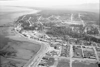
Calmar
-
Description
-
Aerial photograph of Calmar, a town in Central Alberta. An extanse of farmland is visible around the town. Smoke is visible in the background.
-
Date
-
1960
-
-
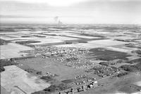
Title
-
Canwood
-
Description
-
Aerial photograph of Canwood, a village in central Saskatchewan.
-
Date
-
1959
-
-
Title
-
Canwood
-
Description
-
Aerial photograph of Canwood, a village in central Saskatchewan.
-
Date
-
1959
-
-
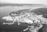
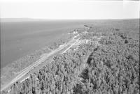
Title
-
Canoe
-
Description
-
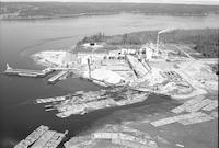
Aerial photograph of the Federated Co-operatives Limited Forest Products Division operations plant in Canoe, British Columbia.
-
Date
-
1958
-
-
Title
-
Canoe
-
Description
-
Aerial photograph of the Federated Co-operatives Limited Forest Products Division operations plant in Canoe, British Columbia.
-
Date
-
1958
-
-
Title
-
Cassidy
-
Description
-
Aerial photograph of Cassidy, a town in Vancouver Island, British Columbia.
-
Date
-
1958
-
-
Title
-
Cassidy
-
Description
-
Aerial photograph of Cassidy, a town in Vancouver Island, British Columbia.
-
Date
-
1958
-
-
Title
-
Cache Creek
-
Description
-
Aerial photograph of Cache Creek, a village in the Thompson Country in British Columbia.
-
Date
-
1958
-
-
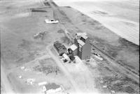
Title
-
Cadillac
-
Description
-
Aerial photograph of Cadillac, a village in southwest Saskatchewan. Several grain elevators and an expanse of farmland are visible in the background.
-
-
Title
-
Cache Creek
-
Description
-
Aerial photograph of Cache Creek, a village in the Thompson Country in British Columbia.
-
Date
-
1960
-
-
Title
-
Cadillac
-
Description
-
Aerial photograph of Cadillac, a village in southwest Saskatchewan. Several grain elevators and an expanse of farmland are visible in the background.
-
-
Title
-
Courtenay
-
Description
-
Aerial photograph of Courtenay, a city on the east coast of Vancouver Island, British Columbia.
-
Date
-
1958
-
-
Title
-
Cache Creek
-
Description
-
Aerial photograph of Cache Creek, a village in the Thompson Country in British Columbia.
-
-
Title
-
Campbell River
-
Description
-
Aerial photograph of a lumber mill in Campbell River, British Columbia.
-
Date
-
1958
-
-
Title
-
Campbell River
-
Description
-
Aerial photograph of a lumber mill in Campbell River, British Columbia.
-
Date
-
1958
-
-
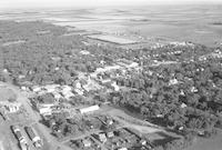
Title
-
Campbell River
-
Description
-
Aerial photograph of Campbell River, a city on the east coast of Vancouver Island, British Columbia.
-
Date
-
1958
-
-
Title
-
Campbell River
-
Description
-
Aerial photograph of Campbell River, a city on the east coast of Vancouver Island, British Columbia.
-
Date
-
1958
-
-
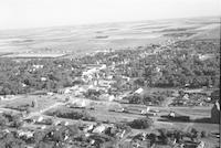
Title
-
Campbell River
-
Description
-
Aerial photograph of Campbell River, a city on the east coast of Vancouver Island, British Columbia.
-
Date
-
1958
-
-
Title
-
Campbell River
-
Description
-
Aerial photograph of Campbell River, a city on the east coast of Vancouver Island, British Columbia.
-
Date
-
1958
-
-
Title
-
Campbell River
-
Description
-
Aerial photograph of Campbell River, a city on the east coast of Vancouver Island, British Columbia.
-
Date
-
1958
-
-
Title
-
Campbellville
-
Description
-
Aerial photograph of Campbellville, a rural community in Ontario.
-
Date
-
1958
-
-
Title
-
Calmar
-
Description
-
Aerial photograph of Calmar, a town in Central Alberta surrounded by farmland.
-
Date
-
1960
-
-
Title
-
Canoe
-
Description
-
Aerial photograph of the Federated Co-operatives Limited Forest Products Division operations plant in Canoe, British Columbia.
-
Date
-
1958
-
-
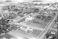
Title
-
Camrose
-
Description
-
Aerial photograph of Camrose, a city in Central Alberta. The Camrose Normal School building is visible in the foreground.
-
Date
-
1959
-
-
Title
-
Canoe
-
Description
-
Aerial photograph of Canoe, a semi-rural community in British Columbia.
-
Date
-
1958
-
-
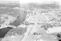
Title
-
Cardinal
-
Description
-
Aerial photograph of Cardinal, a community in the Pembina Valley of Manitoba.
-
Date
-
1957
-
-
Title
-
Cardinal
-
Description
-
Aerial photograph of Bruxelles, community 15 miles west of Cardinal in southern Manitoba. A portion of the wing of the airplane is visible in the left side of the photograph.
-
Date
-
1957
-
-
Title
-
Canborough
-
Description
-
Aerial photograph of Canborough, a community in Southern Ontario.
-
Date
-
1958
-

-
Title
-
Camper
-
Description
-
Aerial photograph of Camper, a community in the Interlake Region of Manitoba.
-
Date
-
1957
-
-
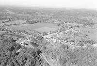
Title
-
Canfield
-
Description
-
Aerial photograph of Canfield, a community in Southern Ontario.
-
Date
-
1958
-
-
Title
-
Cainsville
-
Description
-
Aerial photograph of Cainsville, a community in Southern Ontario.
-
Date
-
1958
-
-
Title
-
Cardross
-
Description
-
Aerial photograph of Cardross, a hamlet in south central Saskatchewan.
-
Date
-
1957
-
-
Title
-
Cardross
-
Description
-
Aerial photograph of Cardross, a hamlet in south central Saskatchewan.
-
Date
-
1957
-
-
Title
-
Cardston
-
Description
-
Aerial photograph of Cardston, a town in southwest Alberta, containing the Cardston Alberta Temple at the center of the image. A church is visible in the foreground. An expanse of farmland is visible in the background.
-
-
Title
-
Carlisle
-
Description
-
Aerial photograph of Carlisle, a community in Hamilton, Ontario.
-
Date
-
1958
-
-
Title
-
Cardinal
-
Description
-
Aerial photograph of Bruxelles, community 15 miles west of Cardinal in southern Manitoba.
-
Date
-
1957
-
-
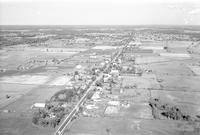
Title
-
Carman
-
Description
-
Aerial photograph of Carman, a small agricultural town in southern Manitoba.
-
Date
-
1957
-
-
Title
-
Carman
-
Description
-
Aerial photograph of Carman, a small agricultural town in southern Manitoba.
-
Date
-
1957
-
-
Title
-
Carman
-
Description
-
Aerial photograph of Carman, a small agricultural town in southern Manitoba.
-
Date
-
1957
-
-
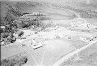
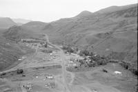
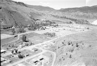
Title
-
Canyon Creek
-
Description
-
Aerial photograph of Canyon Creek, British Columbia, 4 miles west of Wagner.
-
Date
-
1956
Pages


