Error message
Warning: count(): Parameter must be an array or an object that implements Countable in theme_pager_link() (line 637 of /opt/rh/httpd24/root/var/www/html/drupal/web/includes/pager.inc).
Search results
Pages
-
-
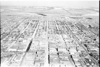
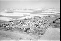
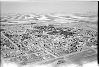
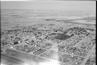
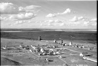
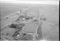
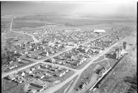
Title
-
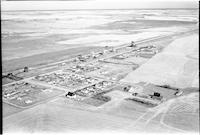
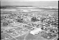
Swift Current
-
Description
-
Aerial photograph of a small city in southern Saskatchewan. An expanse of farmland is visible in the background.
-
-
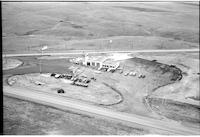
Title
-
Esso Service Station
-
Description
-
Aerial photograph of the Esso Service Station in Swift Current, Saskatchewan.
-
-
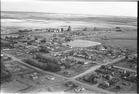
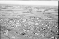
Title
-
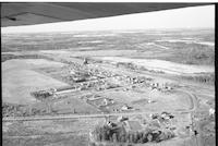
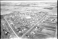
Struan
-
Description
-
Aerial photograph of small town surrounded by farmland dotted with trees.
-
-
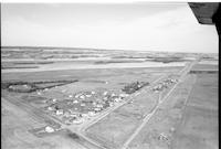
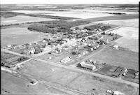
Title
-
Wyatt
-
Description
-
Aerial photograph of a small community with expansive farmland in the background.
-
-
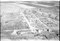
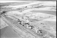
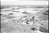
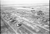
Title
-
Vanguard
-
Description
-
Aerial photograph of a village surrounded by farm land. Main street, the railroad, grain elevators, and a quonset dominate the scene.
-
-
Title
-
Tompkins
-
Description
-
Aerial photograph of a village with farm land beyond the town. Grain elevators, the railroad, and a hotel are clearly visible.
-

-
Title
-
Tompkins
-
Description
-
Aerial photograph of a village with a large church in the foreground.
-

-
Title
-
Shell Lake
-
Description
-
Aerial photograph of a small agricultural village. An expanse of forest and farmland is visible in the background.
-
-
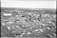
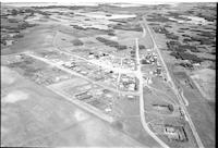
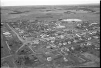
Title
-
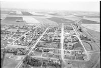
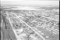
Tisdale
-
Description
-
Aerial photograph of a large agricultural town and business center. An expanse of farmland is visible in the background.
-
-
Title
-
Sedley
-
Description
-
Aerial photograph of a small village surrounded by farmland.
-
-
Title
-
Shaunavon
-
Description
-
Aerial photograph of a town with a checkerboard of farmland in the background.
-
-
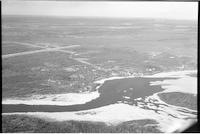
Title
-
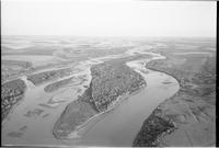
Stony Rapids
-
Description
-
Aerial photograph of a northern hamlet adjacent to the Fond du Lac River.
-
-
Title
-
Verwood
-
Description
-
Aerial photograph of a hamlet with a large church in the background.
-
Date
-
, 1955
-
-
Title
-
Wilmar
-
Description
-
Aerial photograph of an unincorporated hamlet surrounded by farmland, the landscape dotted with clusters of trees. The shadow of an airplane can be seen at the bottom of the photograph.
-
Date
-
, 1955
-
-
Title
-
Willows
-
Description
-
Aerial photograph of a hamlet sloping down towards a valley.
-
Date
-
, 1955
-

-
Title
-
Paradise Hill
-
Description
-
Aerial photograph of the village of Paradise Hill, showing surrounding forested rolling hills.
-
-
Title
-
Sonningdale
-
Description
-
Aerial photograph of an agricultural hamlet surrounded by farmland.
-

-
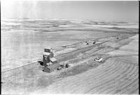
Title
-
Sclanders
-
Description
-
Aerial photograph of two grain elevators within the small community of Sclanders, Saskatchewan.
-
-
Title
-
Shaunavon
-
Description
-
Aerial photograph of a town. The upper half of the picture is farm land.
-
-
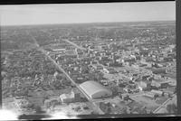
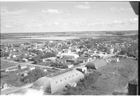
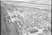
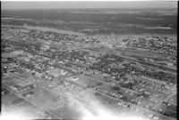
Title
-
Prince Albert
-
Description
-
Aerial photograph of a city.
-
-
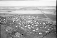
Title
-
Verlo
-
Description
-
Aerial photograph of a hamlet surrounded by a vast expanse of farmland.
-
Date
-
, 1956
-
-
Title
-
Stoughton
-
Description
-
Aerial photograph of a small agricultural town, surrounded by farmland.
-
Date
-
, 1955
-
-
Title
-
Sintaluta
-
Description
-
Aerial photograph of a small town surrounded by farm land. The railroad, school, and main street are easily distinguishable.
-
Date
-
, 1955
-

-
Title
-
Peebles
-
Description
-
Aerial photograph of a hamlet with clusters of trees dotting the landscape.
-
Date
-
, 1955
-
-
Title
-
Sonningdale
-
Description
-
Aerial photograph of an agricultural hamlet surrounded by farmland and small tree stands.
-
-
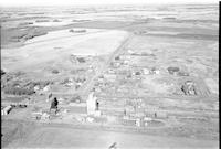
Title
-
Stranraer
-
Description
-
Aerial photograph of a small hamlet surrounded by a vast expanse of farmland.
-
-
Title
-
Shellbrook
-
Description
-
Aerial photograph of a well-sized rural community. An expanse of farmland is visible in the background.
-
-
Title
-
Vanstone
-
Description
-
Aerial photograph of a small rural community surrounded by farmland dotted with trees.
-
-
Title
-
Melfort
-
Description
-
Aerial photograph of a large town with an expanse of farm land in the distance.
-
Date
-
, 1955
-
-
Title
-
Melaval
-
Description
-
Aerial photograph of a small hamlet surrounded by farm land.a
-
Date
-
, 1955
-
-
Title
-
McKague
-
Description
-
Aerial photograph of a community near a forest.
-
Date
-
, 1955
-
-
Title
-
Luseland
-
Description
-
Aerial photograph of a small town with an expanse of farm land in the distance. Main Street, the curling rink, a large park, and a school are all easily visible.
-
-
Title
-
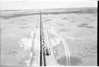
pipeline: Trans Canada 18 miles south of Lancer
-
Description
-
Aerial photograph of the construction of the Trans Canada pipeline, 18 miles south of Lancer.
-
Date
-
, 1956
-
-
Title
-
Gull Lake
-
Description
-
Aerial photograph of a small town surrounded by farm land. The most visible buildings are a quonset and several grain elevators.
-

-
Title
-
Neilburg
-
Description
-
Aerial photograph of a small village. An expanse of farmland is visible in the background.
-
-
Title
-
Melfort
-
Description
-
Aerial photograph of a small city.
-
-
Title
-
Onion Lake
-
Description
-
Aerial photograph of a small community. An expanse of woodland and some farmland is visible in the background.
-
Date
-
, 1956
-
![Willowbunch [Willow Bunch]](/islandora/object/mcphail%3A1309/datastream/TN/view)
-
Title
-
Willowbunch [Willow Bunch]
-
Description
-
Aerial photograph of a small community surrounded by farm land. Grain elevators and the school are easily visible.
-
Date
-
, 1955
-
-
Title
-
Stoughton
-
Description
-
Aerial photograph of small town surrounded by farmland.
-
Date
-
, 1955
-
-
Title
-
Shamrock
-
Description
-
Aerial photograph of a farming community surrounded by an expanse of farmland.
-
Date
-
, 1956
-

-
Title
-
Tway
-
Description
-
Aerial photograph of a hamlet surrounded by farm land. The railroad tracks stretch into the distance, and the church and school are easily visible.
-

-
Title
-
Shell Lake
-
Description
-
Aerial photograph of a small agricultural community. The village is surrounded by forest and farmland.
-
-
Title
-
Stoughton
-
Description
-
Aerial photograph of an agricultural town surrounded by farmland.
-
-
Title
-
Unity
-
Description
-
Aerial photograph of a town with farmland in the background.
-
-
Title
-
Webb
-
Description
-
Aerial photograph of a village with expansive farmland in the background.
-
-
Title
-
Sturgis
-
Description
-
Aerial photograph of an agricultural town surrounded by farmland and trees.
-
Date
-
, 1955
-
-
Title
-
Stoughton
-
Description
-
Aerial photograph of small agricultural town, surrounded by farmland.
-
Date
-
, 1955
-
-
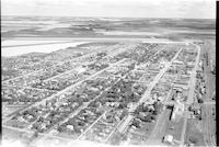
Title
-
Prince Albert
-
Description
-
Aerial photograph of a city situated around a river connected by a bridge.
-

-
Title
-
Southminster
-
Description
-
Aerial photograph of two grain elevators surrounded by an expanse of farmland. The foremost elevator is labelled: "Saskatchewan Pool No. 1096 Southminster B."
-
Date
-
, 1956
-
-
Title
-
Pleasantdale
-
Description
-
Aerial photograph of the village of Pleasantdale surrounded by an expanse of farmland. The village's main street is apparent, as well as a railway in the foreground of the image.
Pages


