Error message
Warning: count(): Parameter must be an array or an object that implements Countable in theme_pager_link() (line 637 of /opt/rh/httpd24/root/var/www/html/drupal/web/includes/pager.inc).
Search results
Pages
-
-
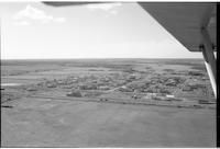
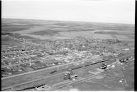
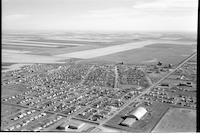
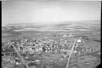
Title
-
St. Boswells
-
Description
-
Aerial photograph of a hamlet surrounded by expansive farmland.
-
Date
-
, 1955
-
-
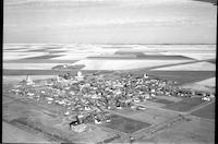
Title
-
Stornoway
-
Description
-
Aerial photograph of an agricultural hamlet surrounded by farmland.
-
Date
-
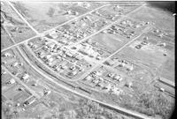
, 1956
-
-
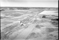
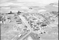
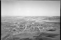
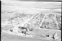
Title
-
Paradise Hill
-
Description
-
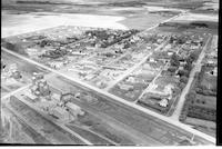
Aerial photograph of Paradise Hill, showing the village's main street, church, and various other dwellings. A railroad runs from lower right to upper left of the photograph.
-

-
Title
-
Tramping Lake
-
Description
-
Aerial photograph of a village surrounded by an expanse of treeless farmland.
-

-
Title
-
Punnichy
-
Description
-
Aerial photograph of the agricultural village of Punnichy surrounded by an expanse of farmland.
-

-
Title
-
Raymore
-
Description
-
Aerial photograph of a town with a large church in the foreground.
-

-
Title
-
Sovereign
-
Description
-
Aerial photograph of a hamlet.
-
-
Title
-
Vesper
-
Description
-
Aerial photograph of a community dominated by farmland. There are some hills in the landscape. It is now a ghost town.
-
-
Title
-
Sutherland
-
Description
-
Aerial photograph of the town of Sutherland before it was incorporated into the City of Saskatoon.
-

-
Title
-
Vawn
-
Description
-
Aerial photograph of a agricultural village so farmland dotted with trees in the background.
-
-
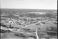
Title
-
Shellbrook
-
Description
-
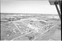
Aerial photograph of a well-sized rural community. An expanse of farmland is visible in the background.
-
-
Title
-
Sonningdale
-
Description
-
Aerial photograph of an agricultural hamlet surrounded by small tree stands and farmland.
-
-
Title
-
Sovereign
-
Description
-
Aerial photograph of a hamlet surrounded by and expanse of farmland.
-
-
Title
-
Strehlow
-
Description
-
Aerial photograph of a community surrounded by farmland.
-

-
Title
-
Stalwart
-
Description
-
Aerial photograph of an organized hamlet in Saskatchewan.
-
-
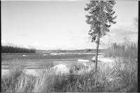
Title
-
Stony Rapids
-
Description
-
Aerial photograph of the landscape near Stony Rapids, a northern hamlet in Saskatchewan. The Fond Du Lac River is visible.
-
-
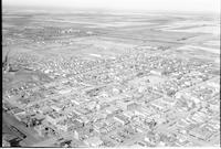
Title
-
Weyburn
-
Description
-
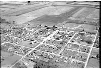
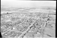
Aerial photograph of a small city. Farm land stretches into the distance. In the upper part of the picture, the Weyburn Mental Hospital, later called the Souris Valley Mental Health Hospital and the Souris Valley Extended Care Centre, is visible, as is the courthouse.
-
Date
-
, 1955
-
-
Title
-
Radville
-
Description
-
Aerial photograph of a town with two large institutions in the centre.
-
Date
-
, 1956
-
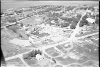
-
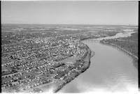
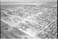
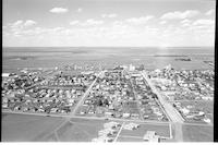
Title
-
Prince Albert
-
Description
-
Aerial photograph of a city with a river cutting through the centre of the picture.
-
-
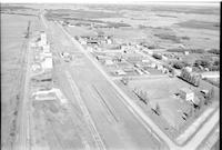
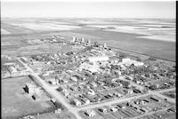
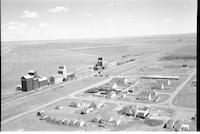
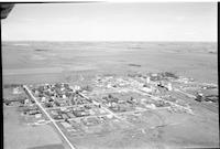
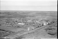
Title
-
Simpson
-
Description
-
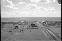
Aerial photograph of a village. The main street, a quonset, the railroad and several grain elevators are clearly visible.
-
-
Title
-
Secretan
-
Description
-
Aerial photograph of a small agricultural community. An expanse of farmland is visible in the background.
-
-
Title
-
Punnichy
-
Description
-
Aerial photograph of a village surrounded by clusters of trees and farmland.
-
-
Title
-
Spiritwood
-
Description
-
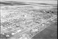
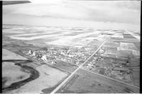
Aerial photograph of a large town on the Prairies.
-
-
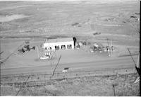
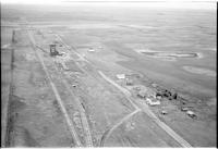
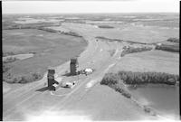
Title
-
North Star Oil
-
Description
-
Aerial photograph of North Star Oil service station. Several vehicles are parked nearby.
-
-
Title
-
Wilcox
-
Description
-
Aerial photograph of small agricultural village surrounded by expansive farmland.
-
Date
-
, 1956
-
-
Title
-
Unity
-
Description
-
Aerial photograph of rural town with farmland in the background.
-
Date
-
, 1953
-
-
Title
-
Trewdale
-
Description
-
Aerial photograph of a community with a grain elevator; farmland dominates the landscape.
-
Date
-
, 1956
-
-
Title
-
Witley
-
Description
-
Aerial photograph of a hamlet with a few grain elevators.
-
Date
-
, 1956
-
-
Title
-
Willow Bunch
-
Description
-
Aerial photograph of a small town containing several grain elevators. Towards the bottom of the image is a stretch of hills, and an expanse of farmland is visible in the background.
-
Date
-
, 1960
-
-
Title
-
Cochin
-
Description
-
Image of a small town with an expanse of lightly forested prairie in the background. The edge of a lake is visible to the left.
-
Date
-
, 1960
-
-
Title
-
Unity
-
Description
-
Aerial photograph of a small town containing several grain elevators. An expanse of farmland is visible in the background.
-
Date
-
, 1960
-
-
Title
-
Isham
-
Description
-
Aerial photograph of a small town with several grain elevators. An expanse of farmland is visible in the background.
-
Date
-
, 1960
-
-
Title
-
Eston
-
Description
-
Aerial photograph of a small town containing several grain elevators. An expanse of farmland is visible in the background.
-
Date
-
, 1959
-
-
Title
-
Kyle
-
Description
-
Aerial photograph of a small town containing several grain elevators. An expanse of farmland is visible in the background.
-
Date
-
, 1959
-
-
Title
-
Hodgeville
-
Description
-
Aerial photograph of a small town containing several grain elevators, which is surrounded by farmland.
-
Date
-
, 1960
-
-
Title
-
Assiniboia
-
Description
-
Aerial photograph of a small town. An expanse of farmland is visible in the background.
-
Date
-
, 1955
-
-
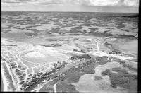
Title
-
Cochin
-
Description
-
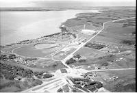
Aerial photograph of a small town next to a lake.
-
Date
-
, 1960
-
-
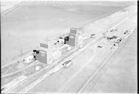
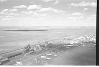
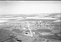
Title
-
Quill Lake
-
Description
-
Aerial photograph of a small town containing several grain elevators. A stretch of farmland is visible in the background.
-
Date
-
, 1960
-
-
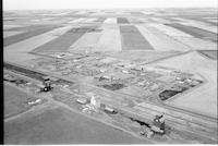
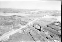
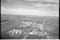
Title
-
Co-op Refinery
-
Description
-
Aerial photograph of a refinery surrounded by farmland.
-
Date
-
, 1960
-

-
Title
-
Tugaske
-
Description
-
Aerial photograph of a small town containing several grain elevators. An expanse of farmland is visible in the background.
-
Date
-
, 1960
-
-
Title
-
Witley
-
Description
-
Aerial photograph of a small hamlet containing two grain elevators which is surrounded by farmland.
-
Date
-
, 1959
-
-
Title
-
Dundurn
-
Description
-
Aerial photograph of a small town containing several grain elevators. An expanse of farmland is visible in the background.
-
Date
-
, 1960
-
-
Title
-
Ceylon
-
Description
-
Aerial photograph of a small town with several grain elevators. An expanse of farmland is visible in the background.
-
Date
-
, 1960
-
-
Title
-
Rosetown
-
Description
-
Aerial photograph of a small town. An expanse of farmland is visible in the background.
-
Date
-
, 1959
-
-
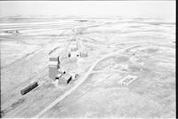
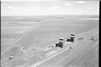
Title
-
Beaverdale
-
Description
-
Aerial photograph of two grain elevators surrounded by lightly wooded prairie and farmland.
-
-
Title
-
Yellow Grass
-
Description
-
Aerial photograph of a small town containing several grain elevators. An expanse of farmland is visible in the background. This image was featured on page 107 of the publication "Portraits of an Era; The Aerial Photograph of Howdy McPhail", written by Bill Waiser and published by Fifth House.
-
Date
-
, 1960
-
-
Title
-
Willow Bunch
-
Description
-
Aerial photograph of a small town containing several grain elevators. Hilly farmland surrounds the town to the bottom and right sides of the image, and a flat expanse of farmland is visible in the background to the left.
-
Date
-
, 1960
-
-
Title
-
Willow Bunch
-
Description
-
Aerial photograph of a small town containing several grain elevators. An expanse of farmland is visible in the background.
-
Date
-
, 1960
-
-
Title
-
Alameda
-
Description
-
Aerial photograph of a small town containing several grain elevators. An expanse of farmland is visible in the background.
-
Date
-
, 1956
-
-
Title
-
Macklin
-
Description
-
Aerial photograph of a small town containing several grain elevators. An expanse of farmland is visible in the background.
-
Date
-
, 1960
Pages


