Search results
-

-
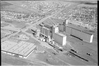
Title
-
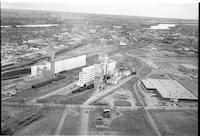
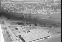
Sask Wheat Pool Flour Mill
-
Description
-
Aerial photograph of the Saskatchewan Wheat Pool Flour Mill in Saskatoon.
-
Date
-
, 1955
-
-
Title
-
Sask Wheat Pool Flour Mill
-
Description
-
Aerial photograph of the Saskatchewan Wheat Pool Flour Mill in Saskatoon.
-
Date
-
, 1955
-
-
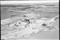
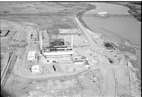
Title
-
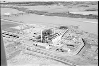
Sask Power plant
-
Description
-
Aerial photograph of the Sask Power plant alongside Spadina Crescent under construction. The power plant is known today as the Queen Elizabeth Power Station operated by SaskPower. The South Saskatchewan River and the Grand Trunk train bridge is visible in the background.
-
-
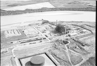
Title
-
Sask Power plant
-
Description
-
Aerial photograph of the Sask Power plant along Spadina Crescent under construction. The power plant is known today as the Queen Elizabeth Power Station operated by SaskPower. The South Saskatchewan River is visible in the background.
-

-
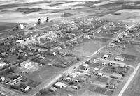
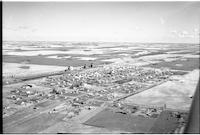
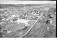
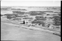
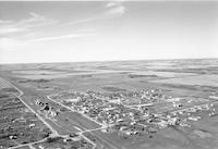
Title
-
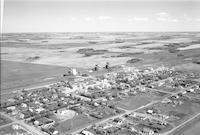
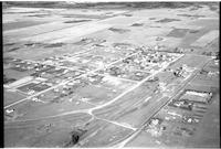
Langham
-
Description
-
Aerial photograph of Langham, a town in central Saskatchewan.
-
Date
-
1959
-
-
Title
-
Langham
-
Description
-
Aerial photograph of Langham, a town in central Saskatchewan.
-
Date
-
1959
-
-
Title
-
Langham
-
Description
-
Aerial photograph of Langham, a town in central Saskatchewan.
-
-
Title
-
Langham
-
Description
-
Aerial photograph of Langham, a town in central Saskatchewan.
-

-
Title
-
Langham
-
Description
-
Aerial photograph of Langham, a town in central Saskatchewan.
-
-
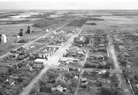
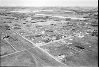
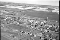
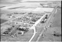
Title
-
Langham
-
Description
-
Aerial photograph of a small town with a church, school, grain elevators, railway tracks, access roads, false fronts and agricultural land visible in background.
-
Date
-
, 1955
-
-
Title
-
Osler
-
Description
-
Aerial photograph of a small town. An expanse of farmland is visible in the background.
-
-
Title
-
Wakaw
-
Description
-
Aerial photograph of a village surrounded by farmland.
-
-
Title
-
Warman
-
Description
-
Aerial photograph of a village surrounded by tree dotted farmland.
-
-
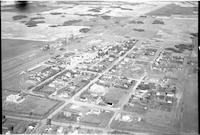
Title
-
Sutherland
-
Description
-
Aerial photograph of the town of Sutherland before it was incorporated into the City of Saskatoon.
-
-
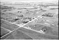
Title
-
Langham
-
Description
-
Aerial photograph of a small town containing several grain elevators, which is surrounded by farmland.
-
Date
-
, 1960
-
-
Title
-
Sask Wheat Pool Flour Mill
-
Description
-
Aerial photograph of the Saskatchewan Wheat Pool Flour Mill in Saskatoon.
-
-
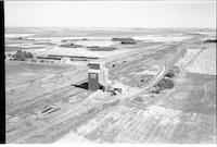
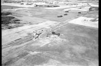
Title
-
Dalmeny
-
Description
-
Aerial photograph of a small town containing several grain elevators. An expanse of farmland is visible in the background.
-
-
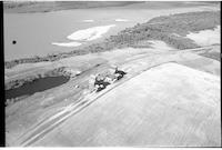
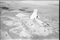
Title
-
Cory
-
Description
-
Aerial photograph of a grain elevator surrounded by farmland.
-
-
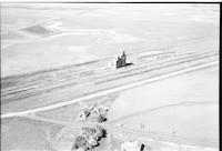
Title
-
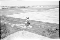
CFQC TV Tower
-
Description
-
Aerial photograph of a television broadcast tower in the middle of a stretch of prairie. A road or highway passes by the tower on the right. A couple of slews are visible near the center of the image.
-
Date
-
, 1955
-
-
Title
-
Dalmeny
-
Description
-
Aerial photograph of a small town containing several grain elevators. an expanse of farmland is visible in the distance, and what appears to be a church building is visible in the center left of the image.
-
-
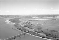
Title
-
Ceepee
-
Description
-
Aerial photograph of two grain elevators next to a river, with a stretch of farmland to the right.
-
-
Title
-
Cheviot
-
Description
-
Aerial photograph of a small hamlet containing two grain elevators. An expanse of farmland is visible in the background.
-
-
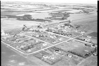
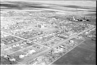
Title
-
Langham
-
Description
-
Aerial photograph of a small town with a church, school, grain elevators, railway tracks, access roads, and agricultural land visible in background.
-
Date
-
, 1955
-
-
Title
-
Osler
-
Description
-
Aerial photograph of a small town. An expanse of farmland is visible in the background.
-
-
Title
-
Diana
-
Description
-
Aerial photograph of a community surrounded by farmland.
-
Date
-
, 1956
-
-
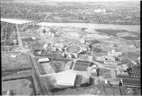
Title
-
University of Sask
-
Description
-
Aerial photograph of the University of Saskatchewan.
-
-
Title
-
Saskatoon
-
Description
-
Aerial photograph of the potash plant in the outskirts of Saskatoon.
-
-
Title
-
Haultain
-
Description
-
Aerial photograph of a small hamlet containing a grain elevator. An expanse of farmland is visible in the background.
-
-
Title
-
Sask Wheat Pool Flour Mill
-
Description
-
Aerial photograph of the Saskatchewan Wheat Pool Flour Mill in Saskatoon.
-
-
Title
-
Grasswood
-
Description
-
Aerial photograph of a grain elevator surrounded by farmland.
-
-
Title
-
Sask Power plant
-
Description
-
Aerial photograph of the Sask Power plant alongside Spadina Crescent under construction. The power plant is known today as the Queen Elizabeth Power Station operated by SaskPower. The South Saskatchewan River is visible in the background.
-
-
Title
-
Sask Power plant
-
Description
-
Aerial photograph of the Sask Power plant alongside Spadina Crescent under construction. The power plant is known today as the Queen Elizabeth Power Station owned and operated by SaskPower. The South Saskatchewan River and the Grand Trunk train bridge is visible in the background.
-
-
Title
-
Ceepee
-
Description
-
Aerial photograph of Ceepee, a community in central Saskatchewan.
-
Date
-
1959
-
-
Title
-
Dalmeny
-
Description
-
Aerial photograph of Dalmeny, a town in central Saskatchewan.


