Search results
Pages
-
-
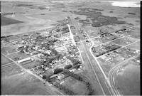
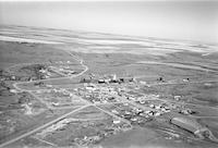
Title
-
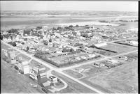
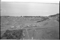
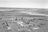
Cut Knife
-
Description
-
Aerial photograph of a small town with dwellings, churches, grain elevators, railway, and agricultural land.
-
Date
-
, 1956
-
-
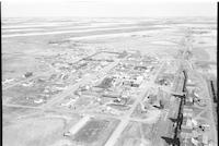
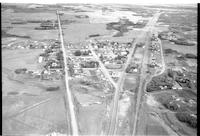
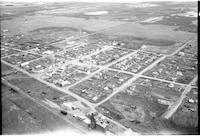
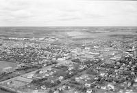
Title
-
Coleville
-
Description
-
Aerial photograph of a small town, grain elevators, railway tracks, train station, water tower, church and agricultural land.
-
Date
-
, 1955
-

-
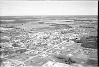
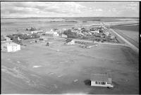
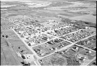
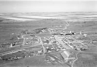
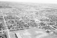
Title
-
St. Walburg
-
Description
-
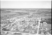
Aerial photograph of an agricultural town surrounded by farmland and lightly wooded prairie.
-
![Cochin [farms]](/islandora/object/mcphail%3A803/datastream/TN/view)
-
Title
-
Cochin [farms]
-
Description
-
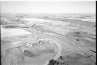
Aerial photograph of an unidentified farm near Cochin.
-
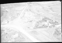
-
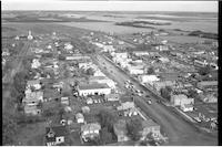
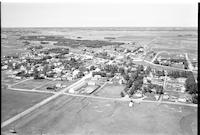
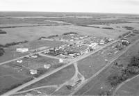
Title
-
Cut Knife
-
Description
-
Aerial photograph of a small town with churches, dwellings, vehicles on a main street, store fronts with a service station. Agricultural land in the background.
-
![Cochin [farms]](/islandora/object/mcphail%3A799/datastream/TN/view)
-
Title
-
Cochin [farms]
-
Description
-
Aerial photograph of an unidentified farm.
-
-
Title
-
St. Walburg
-
Description
-
Aerial photograph of an agricultural town surrounded by farmland and wooded prairie.
-
-
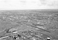
Title
-
Biggar
-
Description
-
Aerial photograph of grain elevators, livestock corral, railway tracks and agricultural land.
-
-
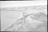
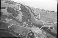
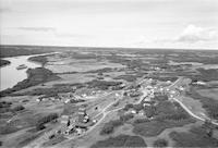
Title
-
Cochin
-
Description
-
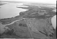
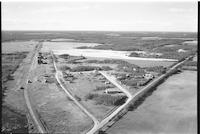
Aerial photograph of a resort village. Jackfish Lake or Murray Lake is in the distance.
-
-
Title
-
Cochin
-
Description
-
Aerial photograph of a resort village. Jackfish Lake Narrows Bridge spans Lehman Creek, a channel that connects Jackfish Lake and Murray Lake.
-
-
Title
-
Primate
-
Description
-
Aerial photograph of a hamlet. An expanse of farmland is visible in the background.
-
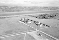
![Cochin [farms]](/islandora/object/mcphail%3A819/datastream/TN/view)
-
Title
-
Cochin [farms]
-
Description
-
Aerial photograph of an unidentified farm. Large bodies of water lie on either side of the farm.
-
-
Title
-
Cochin
-
Description
-
Aerial photograph of a resort village. Jackfish Lake Narrows Bridge spans Lehman Creek, a channel that connects Jackfish Lake and Murray Lake.
-
-
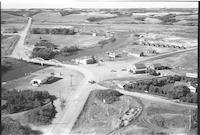
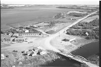
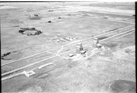
Title
-
Court
-
Description
-
Aerial photograph of a hamlet with grain elevators, farmland, dwellings, railway tracks and agricultural land in background.
-
-
Title
-
St. Walburg
-
Description
-
Aerial photograph of an agricultural town with an expanse of farmland visible in the background.
-
![Cochin [farms]](/islandora/object/mcphail%3A823/datastream/TN/view)
-
Title
-
Cochin [farms]
-
Description
-
Aerial photograph of an unidentified farm near Cochin.
-
-
Title
-
Robinhood
-
Description
-
Aerial photograph of a hamlet. An expanse of farmland is visible in the background.
-
-
Title
-
Cochin
-
Description
-
Aerial photograph of a resort village. Jackfish Lake Narrows Bridge spans Lehman Creek, a channel that connects Jackfish Lake and Murray Lake.
-
-
Title
-
Cochin
-
Description
-
Aerial photograph of a resort village. Jackfish Lake Narrows Bridge spans Lehman Creek, a channel that connects Jackfish Lake and Murray Lake.
-
-
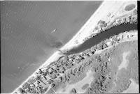
Title
-
Cochin
-
Description
-
Aerial photograph of a resort village. A boat is on the lake, either Jackfish or Murray. A series of houses are along Lehman Creek, a channel that connects Jackfish Lake and Murray Lake.
-
-
Title
-
Rosetown
-
Description
-
Aerial photograph of a large town. An expanse of farmland is visible in the background.
-
Date
-
, 1956
-
-
Title
-
Cochin
-
Description
-
Aerial photograph of an incorporated resort village with Jackfish Lake in the background.
-
-
Title
-
Cochin
-
Description
-
Aerial photograph of a resort village. Jackfish Lake Narrows Bridge spans Lehman Creek, a channel that connects Jackfish Lake and Murray Lake.
-
![Cochin [farms]](/islandora/object/mcphail%3A853/datastream/TN/view)
-
Title
-
Cochin [farms]
-
Description
-
Aerial photograph of an unidentified farm.
-
-
Title
-
Ruthilda
-
Description
-
Aerial photograph of an agricultural village. An expanse of farmland is visible in the background.
-
-
Title
-
Cochin
-
Description
-
Aerial photograph of a resort village. Jackfish Lake and Lehman Creek are visible.
-
-
Title
-
Radisson
-
Description
-
Aerial photograph of a small town. An expanse of farmland is visible in the background.
-
-
Title
-
Borden
-
Description
-
Aerial photograph of a small town with dwellings, barns, access roads, highway, lumber yard, grain elevators, railway tracks and cropland in the background.
-
-
Title
-
St. Walburg
-
Description
-
Aerial photograph of an agricultural town surrounded by farmland and wooded prairie.
-

-
Title
-
St. Hippolyte Church
-
Description
-
Aerial photograph of St. Hippolyte Roman Catholic Church west of Vawn, Saskatchewan. The church is surrounded by homes and agricultural structures. Farmland and wooded prairie is visible in the background.
-
-
Title
-
Radisson
-
Description
-
Aerial photograph of a small village. An expanse of farmland is visible in the background.
-
-
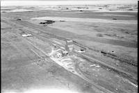
Title
-
Salter
-
Description
-
Aerial photograph of two grain elevators beside a railroad in the middle of agricultural land.
-
-
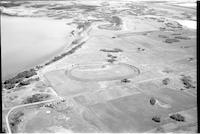
Title
-
Cochin
-
Description
-
Aerial photograph of the sports grounds and race track.
-
-
Title
-
St. Walburg
-
Description
-
Aerial photograph of an agricultural town surrounded by farmland and lightly wooded prairie.
-
-
Title
-
Cochin
-
Description
-
Aerial photograph of a resort village.
-

-
Title
-
St. Hippolyte Church
-
Description
-
Aerial photograph of St. Hippolyte Roman Catholic Church west of Vawn, Saskatchewan. The church is surrounded by farmland.
-
-
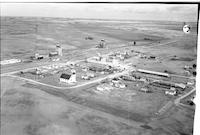
Title
-
Fielding
-
Description
-
Aerial photograph of Fielding, a community in western Saskatchewan.
-
Date
-
1959
-
-
Title
-
Fort Battleford
-
Description
-
Aerial photograph of Fort Battleford, Saskatchewan.
-
-
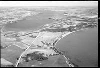
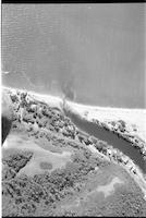
Title
-
Frenchman Butte
-
Description
-
Aerial photograph of Frenchman Butte, Saskatchewan. A river is visible in the left.
-
Date
-
1957
-
-
Title
-
Herschel
-
Description
-
Aerial photograph of Herschel, a former village in western Saskatchewan.
-
Date
-
1959
-
-
Title
-
Herschel
-
Description
-
Aerial photograph of Herschel, a former village in western Saskatchewan.
-
Date
-
1959
-
-
Title
-
Livelong
-
Description
-
Aerial photograph of Livelong, a hamlet in western Saskatchewan.
-
Date
-
1957-09
-

-
Title
-
Livelong
-
Description
-
Aerial photograph of Livelong, a hamlet in western Saskatchewan.
-
Date
-
1957-09
-
-
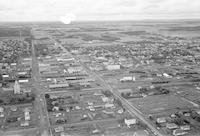
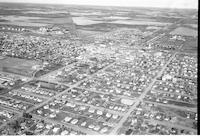
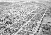
Title
-
Lloydminster
-
Description
-
Aerial photograph of Lloydminster, a city straddling the provincial border between Saskatchewan and Alberta.
-
Date
-
1955
-
-
Title
-
Lloydminster
-
Description
-
Aerial photograph of Lloydminster, a city straddling the provincial border between Saskatchewan and Alberta.
-
Date
-
1955
-
-
Title
-
Lloydminster
-
Description
-
Aerial photograph of Lloydminster, a city straddling the provincial border between Saskatchewan and Alberta.
-
Date
-
1955
-
-
Title
-
Lloydminster
-
Description
-
Aerial photograph of Lloydminster, a city straddling the provincial border between Saskatchewan and Alberta.
-
Date
-
1956
-
-
Title
-
Lloydminster
-
Description
-
Aerial photograph of Lloydminster, a city straddling the provincial border between Saskatchewan and Alberta.
-
Date
-
1956
Pages


