Error message
Warning: count(): Parameter must be an array or an object that implements Countable in theme_pager_link() (line 637 of /opt/rh/httpd24/root/var/www/html/drupal/web/includes/pager.inc).
Search results
Pages
-
-
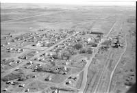
Title
-
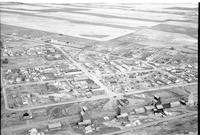
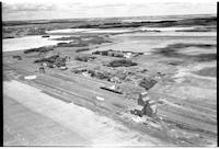
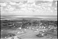
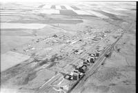
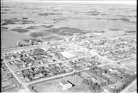
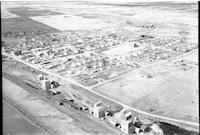
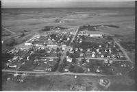
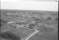
Hodgeville
-
Description
-
Aerial photograph of a village with farm land in the distance. The main street of the town is easily visible, as are a church, the railroad, and several grain elevators.
-
Date
-
, 1955
-

-
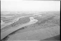
Title
-
North Battleford: North Saskatchewna River
-
Description
-
Aerial photograph of the North Saskatchewan River near North Battleford. An expanse of farmland is visible in the background.
-
-
Title
-
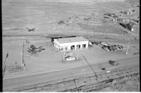
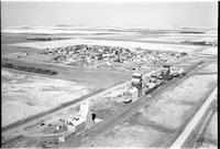
North Battleford
-
Description
-
Aerial photograph of a garage in North Battleford.
-
Date
-
, 1955
-
-
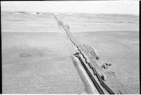
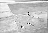
Title
-
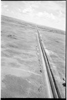
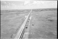
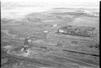
pipeline: Trans Canada 18 miles south of Lancer
-
Description
-
Aerial photograph of the construction of the Trans Canada pipeline, 18 miles south of Lancer.
-
Date
-
, 1956
-
-
Title
-
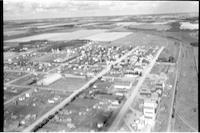
Naicam
-
Description
-
Aerial photograph of a small town. An expanse of farmland is visible in the background.
-
-
Title
-
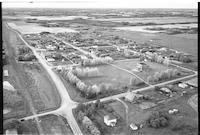
Onward
-
Description
-
Aerial photograph of a hamlet surrounded by expansive farmland.
-
-
Title
-
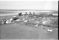
Lloydminster
-
Description
-
Aerial photograph of a small town with dwellings, churches, grain elevators and agricultural land in the background.
-
Date
-
, 1956
-
-
Title
-
Lloydminister
-
Description
-
Aerial photograph of small town with schools, churches, dwellings, a water tower, grain elevators and a railroad. Agricultural land is visible in the background.
-
-
Title
-
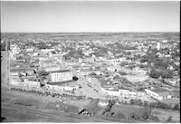
North Battleford
-
Description
-
Aerial photograph of a service station outside of a small city. The service station is named "Townmann's Service Station."
-
-
Title
-
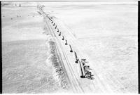
pipeline: Trans Canada 18 miles south of Lancer
-
Description
-
Aerial photograph of the construction of the Trans Canada pipeline, 18 miles south of Lancer.
-
Date
-
, 1956
-
-
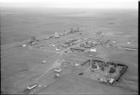
Title
-
Paswegin
-
Description
-
Aerial photograph of a small agricultural community. An expanse of farmland is visible in the background.
-
-
Title
-
Plenty
-
Description
-
Aerial photograph of a small village. An expanse of farmland is visible in the background.
-
-
Title
-
Pambrun
-
Description
-
Aerial photograph of a town. To the left is extensive farmland.
-
-
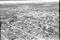
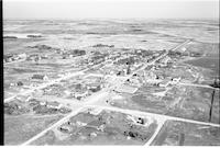
Title
-
North Battleford
-
Description
-
Aerial photograph of a small city.
-
-
Title
-
Palmer
-
Description
-
Aerial photograph of a small agricultural town. An expanse of farmland is visible in the background.
-
Date
-
, 1956
-
-
Title
-
North Battleford: North Saskatchewna River
-
Description
-
Aerial photograph of the North Saskatchewan River. North Battleford is visible to the right of the river.
-
-
Title
-
pipeline: Trans Canada 18 miles south of Lancer
-
Description
-
Aerial photograph of the construction of the Trans Canada pipeline, 18 miles south of Lancer.
-
Date
-
, 1956
-
-
Title
-
Outlook
-
Description
-
Aerial photograph of a small town. An expanse of farmland is visible in the background.
-
-
Title
-
Pontrilas
-
Description
-
Aerial photograph of a small farming community.
-
-
Title
-
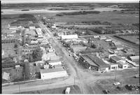
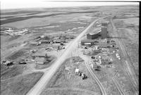
Neilburg
-
Description
-
Aerial photograph of a small village. The main street is lined with shops.
-
-
Title
-
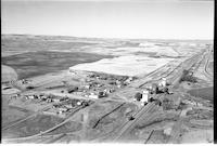
Herbert
-
Description
-
Aerial photograph of a town surrounded by farm land.
-

-
Title
-
Paynton
-
Description
-
Aerial photograph of the village of Paynton. The main street is lined with shops, one of which is legible, reading: "WAMAGEE [?]." An excerpt from "Midwest Country": "Paynton was originally settled by three retired constables of the North West Mounted Police in 1888. They were followed by the Barr Colonists and a few hundred other settlers. In 1905, a Village was formed." Midwest Country. ΓÇ£Paynton, SK.ΓÇ¥ Accessed January 16, 2013. http://www.google.com/intl/en/privacypolicy.html.
-
-
Title
-
Neidpath
-
Description
-
Aerial photograph of a small hamlet surrounded by farmland.
-
Date
-
, 1955
-
-
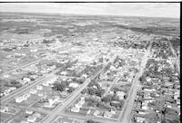
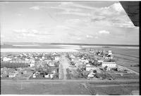
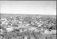
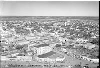
Title
-
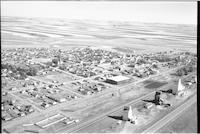
North Battleford
-
Description
-
Aerial photograph of small town with a main Street, store fronts, churches, schools, a railway station and tracks. Dwellings and vehicles fill the streets.
-

-
Title
-
Palmer
-
Description
-
Aerial photograph of a small agricultural town. An expanse of farmland is visible in the background.
-
Date
-
, 1956
-
-
Title
-
Okla
-
Description
-
Aerial photograph of a small community. An expanse of forest is visible in the background.
-
Date
-
, 1956
-
-
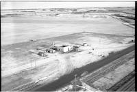
Title
-
North Battleford: Nelson Lumber
-
Description
-
Aerial photograph of Nelson Lumber in North Battleford. The city is visible in the background.
-
-
Title
-
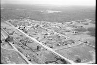
Maidstone
-
Description
-
Aerial photograph of a small town. Grain elevators, main street, the school and the curling rink are the dominant features.
-
-
Title
-
Hatfield
-
Description
-
Aerial photograph of a very small community, surrounded by farmland.
-
Date
-
, 1955
-

-
Title
-
Paynton
-
Description
-
Aerial photograph of the village of Paynton. An excerpt from "Midwest Country": "Paynton was originally settled by three retired constables of the North West Mounted Police in 1888. They were followed by the Barr Colonists and a few hundred other settlers. In 1905, a Village was formed." Midwest Country. ΓÇ£Paynton, SK.ΓÇ¥ Accessed January 16, 2013. http://www.google.com/intl/en/privacypolicy.html.
-
-
Title
-
Paynton
-
Description
-
Aerial photograph of the village of Paynton. An excerpt from "Midwest Country": "Paynton was originally settled by three retired constables of the North West Mounted Police in 1888. They were followed by the Barr Colonists and a few hundred other settlers. In 1905, a Village was formed." Midwest Country. ΓÇ£Paynton, SK.ΓÇ¥ Accessed January 16, 2013. http://www.google.com/intl/en/privacypolicy.html.
-

-
Title
-
Pierceland
-
Description
-
Aerial photograph of an agricultural village in Saskatchewan. An expanse of farmland is visible in the background.
-
Date
-
, 1956
-

-
Title
-
Neville
-
Description
-
Aerial photograph of a small village with farm land stretching into the distance.
-
-
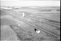
Title
-
pipeline: Trans Canada 18 miles south of Lancer
-
Description
-
Aerial photograph of the construction of the Trans Canada pipeline, 18 miles south of Lancer. A group of cattle is curiously investigating the pipes before they are put in the ground.
-
Date
-
, 1956
-
-
Title
-
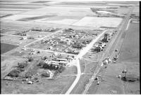
Ogema
-
Description
-
Aerial photograph of a small town with grain elevators, railway tracks, houses, church and a school. Agricultural buildings with agricultural land in the background.
-

-
Title
-
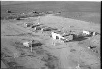
North Battleford
-
Description
-
Aerial photograph of a service station with a small city in the background. The service station is called "Townmann's Service Station."
-
-
Title
-
Osler
-
Description
-
Aerial photograph of a small town. An expanse of farmland is visible in the background.
-

-
Title
-
Neilburg
-
Description
-
Aerial photograph of a small town. The main street is lined with shops.
-
-
Title
-
North Battleford
-
Description
-
Aerial photograph of a service station with people walking on a road, a vehicle, and cattle and agricultural land visible in background.
-
Date
-
, 1955
-
-
Title
-
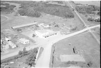
Glaslyn
-
Description
-
Aerial photograph of Dart's Store in a small village. The store is located at the junction of three roads, and the railroad runs nearby.
-
Date
-
, 1956
-
-
Title
-
North Battleford
-
Description
-
Aerial photograph of a small town showing many storefronts, vehicles, hotels, and a water tank. Houses with agricultural land in background.
-

-
Title
-
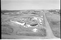
North Battleford
-
Description
-
Aerial photograph of a small city. Two gas stations are in the foreground. The on the left says "Patron Oil Co. Ltd." and the one on the right says "North Star Oil."
-
-
Title
-
Eyebrow
-
Description
-
Aerial photograph of village with houses, a hotel and agricultural land in the background.
-
-
Title
-
Freemantle
-
Description
-
Aerial photograph of a small hamlet with grain elevators, railway tracks and agricultural land in background.
-
-
Title
-
Nokomis
-
Description
-
Aerial photograph of a small town. An expanse of farmland is visible in the background.
-
-
Title
-
Plunkett
-
Description
-
Aerial photograph of a small agricultural village. An expanse of farmland is visible in the background.
-
-
Title
-
Neville
-
Description
-
Aerial photograph of a small village surrounded by farm land. The railroad is the most dominant feature.
-
-
Title
-
Glasnevin
-
Description
-
Aerial photograph of an unincorporated area. Grain elevators, a railroad track, dwellings and agricultural land visible in the background.a
-
Date
-
, 1955
-
-
Title
-
Parkbeg
-
Description
-
Aerial photograph of an agricultural hamlet. An expanse of rolling hills and farmland is visible in the background.
-
-
Title
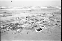
-
Kisby
-
Description
-
Aerial photograph of a small town with grain elevators, a church, school, dwellings, train tracks and agricultural land
-
Date
-
, 1955
Pages


